CHAPTER
1.
INTRODUCTION: HYPOTHESIS
AND SETTING
It
would be difficult to find a reason why the Indians should
care one way or another if the forest burned. It is quite something else again to contend
that the Indians used fire systematically to "improve" the
forest . . . yet this
fantastic idea has been and still is put forth time and again.
When the forest burned, fires were often
of high intensity and uncontrollable. The tribes of coastal
Oregon were the victims of some of these fires, having been driven
to the waters
of the Pacific Ocean to survive.
James Agee 1993:
56
Between 1840 and 1850 an abrupt transformation
took place in western Oregon that resulted in permanent and large-scale
changes to the region's forest and grassland environments. During
that decade dozens of local American Indian nations and tribes were
all but replaced by a comparatively homogenous population of European
American
immigrants. Many wildlife species were subsequently decimated
and extirpated in favor of domesticated plants and animals: California
condors,
grizzly bears, wolves, and whitetail deer gave way to chickens, cattle
and swine; fields of camas and tarweed were transformed to corn, potatoes
and
wheat. Even
fire was affected. Expansive grasslands that were annually fired
to produce and harvest food crops were plowed and grazed instead. Interior
forestland trails, prairies, meadows, brakes, and berry patches--created
and maintained by fire--were abandoned and began converting to trees. Near
the end of the decade, probably in 1849 or 1850, the first of a century-long
series of catastrophic forest fires took place in the region. These
wildfires were so large and notable they became known as the "Great
Fires" and
acquired individual names: the Yaquina, the Coos, the Nestucca, the Tillamook.
This thesis examines the change in vegetation
patterns of the Coast Range of western Oregon (see
Map 1.01)
from late pre-European contact ("precontact") time: beginning in the
late 15th century, in 1491 (before European diseases were introduced
into North America); through early historical time, until 1951 (the
year of the last significant Tillamook
fire). It
is the first study to place the region's precontact cultural landscape
patterns in context to the fuel histories and boundaries of subsequent
forest wildfires.
A certain amount of history has been written
and documented about the Oregon Coast Range ("Coast Range" or "the
Range") forest fires of ca. 1849 to 1951 (e.g., Gannett 1902;
Morris 1934b; Pyne 1982), but--with the notable exception
of the Willamette
Valley and the eastern slope of the Range--very little has been written
about pre-European contact ("precontact") Indian burning
practices in the area. Eyewitness
accounts of David Douglas from 1825 to 1827 (Douglas 1905; 1906), John
Work from 1832 to 1834 (e.g., Elliot 1925),
by members of the 1841 Wilkes Expedition (Wilkes 1845), and others,
have described the times,
locations
and results
of Indian burning practices along the eastern slope and floodplains
of the Coast Range. Early
paintings (e.g., Warre 1845; Kane 1847) and land surveys (e.g., Preston
1851; Hathorn 1855) added detail to the written descriptions of the
original journalists. Drawing
from these resources, subsequent writers and geographers
(e.g., Morris 1934; Johannessen et al. 1971; Thilenius 1972), have
been able to construct reasonably accurate maps and accounts of
the burning
practices and results of Kalapuyans who occupied the territory (e.g.,
Mackey 1974; Gilsen XX, Boyd
1986). By comparison, very little has been documented
regarding the burning practices of late prehistoric and early historical
people
living
in the northern, western, and southern parts of the region (see
Map 1.01).
Map 1.01 Location
of the Oregon Coast Range study area.
LaLande and Pullen (1999: 267) term Indian
fires in the southern Coast Range "limited and localized" in the "mid-elevation,
mixed conifer forest stands" which characterize the "vast" majority
of the area. Whitlock and Knox (2002: 224) go even further, claiming
the presence
of early historical prairies, savannah, and oak woodlands in the Coast
Range were a direct result of prehistoric climate change and lightning-caused
fires ("which were probably more abundant . . . in the early Holocene":
p.206), and had relatively little or nothing to do with human burning
practices. Through
the use of maps, tables, eyewitness accounts, drawings, and photographs,
this thesis documents the use of fire by American Indian people living
in the Oregon Coast Range at the time of contact with white Europeans
and Americans in the late 1700s. The same methods are used to
describe the subsequent Great Fire events of 1849-1951 and the roles
Indian fires
may have played in their timing, severity, location, and boundaries.
A. Hypothesis
The hypothesis of this dissertation is that
western Oregon patterns of 16th to mid-19th century Indian burning practices
had a direct effect on patterns of catastrophic forest fires that took
place from 1849 to 1951 in the Oregon Coast Range.
Indian burning practices are defined as those
uses of fire in pre-European American contact time ("precontact
time")
and early historical time that resulted in changed or stabilized landscape-scale
vegetation patterns. Three principal categories of these practices
are recognized: firewood gathering and burning, patch burning, and
broadcast burning (Zybach and Lake 2003). Firewood burning involves
the movement of fuels to specific locations
before burning, resulting in areas that contained relatively little
(or stockpiled) large, woody debris and designated spots of intense,
repeated
and prolonged heat. Patch burning is defined as having a specific
purpose and involving fuels within a bounded area, such as burning
an older huckleberry patch, a segment of trail, or a field of weeds.
Broadcast burning
is the practice of setting fire to the landscape for multiple purposes
and with general boundaries, such as burning a prairie to cure tarweed
seeds, eliminate Douglas-fir seedlings, expose reptiles and burrowing
mammals, and to harvest insects.
Maps, tables, and figures are used to show differences
in cultural landscape patterns resulting from Indian burning practices. Cultural
landscape patterns are landscape-scale designs created and maintained
by systematic human burning (and/or by other land management processes),
due
to their origin and appearance (Bailey and Winkler 2001). Landscape
patterns, for purposes of this dissertation, are considered at regional
(hundreds of thousands or millions of acres), basin (thousands or tens
of thousands of acres), and local (dozens or hundreds of acres) scales. These
patterns are shown to vary between northern, eastern, western, and
southern parts of the Coast Range due to differences in national and
tribal traditions,
topography, climate, vegetation, and distance from the ocean. The "cultural
legacy" of combined burning actions is shown to have a direct
effect on subsequent patterns of catastrophic forest fires in the same
region. Cultural
legacy is defined as the evidence of trails, savannah, prairies, fields,
berry patches, brakes, balds and other environmental indications of
human land uses that persist through time. Catastrophic fires
are defined as wildfire events that are greater than 100,000 acres
in size. Patterns
of burning and wildfire include similarities and differences in sources
and locations
of ignition; locations and extent of fire boundaries; timing, frequency,
seasonality, and intensity of fires; and effects of fire on local human
and wildlife populations.
The terms "Indian" and "American Indian" will
be used interchangeably to denote people who lived in the Oregon Coast
Range in precontact and early historical time, in accordance with current
and accepted use of these terms by the peers and descendents of these people. "Tribes" will
be used in the same manner as currently used by the Confederated Tribes
of Siletz, Confederated Tribes of Grand Ronde, Coquille Indian Tribe, and
the Confederated Tribes of Coos, Lower Umpqua, and Siuslaw. "Nation" will
be used to designate adjacent Indian tribes associated by proximity and
a shared language, such as the Chinook Nation of the 1940s that became
Chinook Indian Tribe, Inc. in 1953: specifically the Chinook and Athapaskan
nations on the Columbia, the Kalapuya and Athapaskan nations of the Willamette,
south Umpqua, and upper Coquille valleys, and the Koos, Siuslaw, Yakona,
and Salish nations of the coast. Tribes and nation names will attempt
to use the earliest accepted historical spellings, rather than modernized
spellings or European terms. "White" will be used to denote
predominantly European and American Caucasian immigrants to the Coast Range
in early historical time, with the acknowledgement that many of these people
were of Iroquois, Hawaiian, Chinese, or African ancestry. In this
instance, the term "white" is intended to represent people
of western European culture, rather than a particular race or skin
color.
Plants and animals are considered "native" to the Oregon
Coast Range if they were present in the environment before 1770. Species
are referenced by accepted local names, rather than "common" names (e.g.,
"boomer" vs. "mountain beaver"; "chittam" vs. "Cascara buckthorn"),
and are identified by their current scientific latin names in Appendix
A.
B. Physical
Setting
This dissertation concerns people, fire, and the use
of fire by people in a particular region of western North America. People
first entered the Oregon Coast Range more than 10,000 years ago, probably
by foot or watercraft. The use of fire by people in the region was
coincidental with their arrival; if people didn't arrive with fire, they
probably manufactured it within a few hours or days. The environment
began to be transformed immediately. For the first time ever, firewood
was gathered, forests were purposefully fired, and grasslands burned. As
human settlements became more permanent, so did patterns of human use upon
the land. This section briefly describes the history of the land
these people found, where they settled and why, and how the shape of the
land helped to shape the patterns of people and their fires across the
landscape.
A region's topography is largely a result of its geological
history. The formation of the Coast Range is relatively young compared
to other areas of the earth and of the Pacific Northwest. Its soils
and elevations are traced largely to the erosion of older landmasses, undersea
volcanic eruptions, tectonic plate uplift, and a series of cataclysmic
floods. According to Orr, et al. (1992: 167-202), the beginnings
of the Coast Range are thought to have been about 66 million years ago,
with underwater eruptions of basaltic pillow lavas that can now be seen
on the shoreline of Depoe Bay, throughout the Siletz River Gorge, and as
far east as Coffin Butte, along Highway 99 on the eastern boundary of Soap
Creek Valley. During the same period, the Klamath Mountains in present-day
southwest Oregon were steadily eroding, filling the shallow ocean to their
north with sediments that would ultimately become the Tyee soils and sandstones
of today. Ash and pyroclastics from infant Cascade volcanoes to the
east were added to the mix, and the steady collision of the Juan de Fuca
tectonic plate with the North American continental shelf forced the mass
to rise above sea level and moved the Pacific shoreline west. River
valleys and peaks were formed by erosion over millions of years; while
rising and lowering seas carved the western boundary and upland terraces. Lava
flows emanating from eastern Oregon 15 million years ago added further
definition to the Range. From 12,800 to 15,000 years ago, a series
of ice age floods coursed down the Columbia River, shaping the bluffs and
islands along the northern boundary of the Coast Range, and leveling the
floodplain of the Willamette Valley from Eugene to Oregon City with soils
from eastern Washington, Idaho, and Canada (Allen 1982). About
5,000 years ago the region achieved its current general configuration,
as melting
ice caused a worldwide rise in sea levels, flooding coastal river
valleys and creating the bays, estuaries, and beaches found today
(Orr, et al.
1992: 181-182).
These events all contributed to the topography of the
Coast Range, directly effecting patterns of human settlement and
land
use, including fire, from the time of discovery, more than 10,000
years ago,
to the present. In general, people have congregated and settled near
the mouths of most major rivers and bays, whether lesser villages and campgrounds
established along the low gradient areas accessible by canoe or other watercraft. Upland
prairies, brakes, berry patches, and grassy balds were heavily used on
a seasonal basis, and were connected by a series of ridgeline foot-trails. Fire
was daily, and depended entirely on gathered fuel in the heavily populated
areas and in seasonal campgrounds. Fire was used seasonally to burn
expanses of "root prairies", hunt, cure tarweed, rejuvenate
huckleberries, etc., in eastern oak savannahs and in upland prairies
and berry patches,
along ridgeline brakes, and southern slopes and balds.
Fire is said to behave according to ignition patterns
constrained by three sides of a "triangle," defined as
weather, fuels, and topography (e.g., Martin 1990: 58). In
general, shrubs, trees, and other forest fuels will burn more readily
and completely
in hot, dry weather driven by wind, rather than in cool, moist
weather or
in still air (ibid.: 59). Likewise, fire travels faster and
hotter moving uphill rather than down, covers the landscape more
completely
over rolling terrain rather than "skipping" across flatlands,
and tends to burn drier fuels on sunny south slopes rather than
shady north
slopes (ibid.: 58). Therefore, the topography of an area
has a controlling effect on local fire behaviors and helps to define
resulting
patterns of
burned and surviving vegetation. Topography includes slope
(steepness of terrain), aspect (which direction the terrain faces),
and elevation
above sea level. Map 1.02 shows
the Coast Range as sloping steeply east and west from a central
north-south ridgeline that runs nearly its
entire length. On the west it is bordered at sea level by
the Pacific Ocean; the Columbia River is subject to tidal influence
along
its entire northern
border; and the Willamette Valley floodplain extends for miles
on a nearly flat plane along many portions of its eastern boundary. Its
highest point is near the center of the Range, where Marys Peak
reaches more than
4,000 feet elevation.
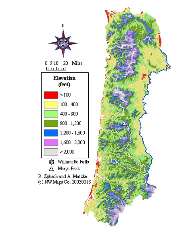
Map 1.02 Topography of the
Oregon Coast Range.
People prefer to live at the mouths of rivers and creeks
and to reside around bays and in valleys in the Oregon Coast
Range
for the same reasons they have always done so: freshwater; ready
transport;
access to terrestrial, marine and riverine foods; aesthetics. Currently,
most people who live in the Coast Range reside near the mouth
of the Willamette River, near the mouths of its tributaries,
near the mouth
of the Columbia
River, or along the bays and estuaries of coastal rivers (see
Map 1.03). Early
journalists (e.g., Howay, 1788; Lewis and Clark, 1805-1806; Alexander
R. McLeod, 1826-1828; Charles Wilkes, 1841) have reported similar
distributions
of people in early historical time; archaeologists (e.g., Strong: XX;
Hall: XX; Aikens: XX) have found the same patterns for prehistoric
time as well. Until recently, when people began to heat
their homes with electricity, steam, coal, and oil instead of
wood, and began to use automobiles
instead of feeding herds of ungulates for food or transportation,
areas of Coast Range settlement were quartered in grasslands, had relatively few trees, and most dead wood
was found gathered
or stacked for later use
in ovens, stoves, or firepits. No
evidence has been found that is contrary to this assessment, and it is
difficult to imagine a circumstance that would allow for much difference.
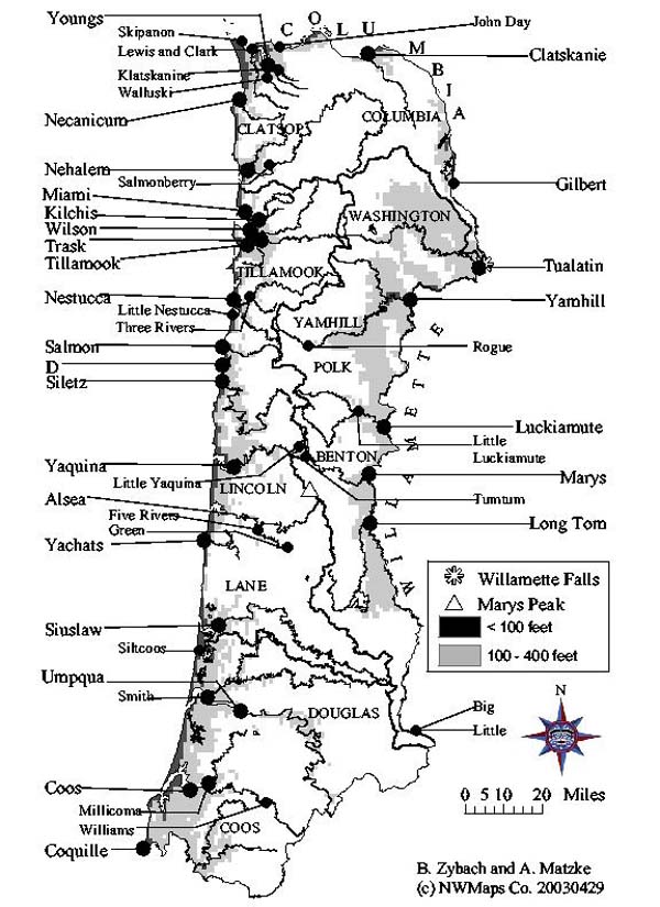
Map 1.03 Rivers and counties
of the Oregon Coast Range.
The fact that people become associated with the rivers
and valleys
they occupy is demonstrated by the names on the land of the Oregon
Coast Range. Rivers entering the Pacific Ocean from the east
are named Coquille, Coos, Umpqua, Siuslaw, Alsea, Yaquina, Nestucca, Tillamook,
and Nehalem; after the precontact communities that lived along their bays
and traveled their lengths by foot and canoe. Rivers that enter the
Columbia from the south are named Clatsop, Klaskanie, and Clatskanie for
the same reason. Rivers entering the Willamette from the west are
named Long Tom, Luckiamute, Yamhill, and Tualatin, also for the same reason. Even
the original historical name for the Willamette--Multnomah--was for a people
that lived on Sauvies Island, near the river's mouth. It is reasonable
to assume that most intensive firewood gathering, firewood use, trail development,
and patch burning in precontact time took place near the mouths of these
streams and along the low gradient areas most amenable to foot and canoe
traffic. Early historical records and early historical settlement
patterns support this assumption.
C. Climate
and Weather
The second side of the "fire behavior triangle",
after topography,
is weather. Weather is the
combination
of temperature, precipitation,
humidity, airflow, and related
phenomena (such as cyclones
and lightning) that is occurring
now; climate is the combination
of averages, seasonality, and
extremes of these elements
over time (Taylor and Hannan
1999).
Oregon Coast Range climate is classified
as a northern extension of
the Mediterranean climate that
characterizes coastal California,
with similar seasonal distributions
but cooler temperatures and
a longer rainy season. This
means the year has two general
seasons; a mild, wet winter
and a warm, dry summer. There
is little snow most years,
except for the highest peaks,
and that is usually melted
by late spring. Likewise, most
years have few--if any--days
that reach a 100 F. temperature
(Redmond and Taylor 1997: 34).
Most precipitation falls in the
form of rain during the "wet" season
from October to March, during which time most days are
cloudy and moist (Redmond and Taylor 1997: 28).
Map
1.04 shows average annual rainfall for the Oregon Coast
Range
for
a
30-year
period
from
1961
to
1991.
Notice
that
the
wetter lands
tend
toward the
northernmost
peaks
of
the highest
elevations.
The
driest
land is
in
the
eastern
Coast
Range,
and coastal
beaches
have
less
measurable
rainfall
(but
far more
fog),
than
Douglas-fir
forestlands
a few
miles
inland
and a
few
hundred
feet higher
elevation.
Snow.
The snows of 1861, 1881-82
(Lee and Jackson, 1984: 42)
and October, 1936 (Starker,
1939: 47) were all noted for
the vast amounts of livestock
they killed on the ranges of
the Willamette Valley and eastern
Coast Range. Prairie lands
that had been cleared and
maintained by Indian fires
had subsequently been kept
clear of tree growth by grazing
cattle, horses, sheep, pigs,
and goats. There is some evidence
that reductions in grazing
associated with the livestock
mortality of those years
resulted in the spreading
of Douglas-fir to many former
hillside pasturages (CITE).
Starker also mentions a "a similar wet
snow about twenty years previous" to
the 1936 event that apparently broke the tops and limbs
off a number of trees in
the Soap Creek area and covered the ground with debris from the breakage.
2) Temperature
and Humidity
Table
1.01 was
assembled
between 1961
and
1991
from
weather
data
stations
marked
with
white
dots
and
their
names
on
Map
1.04.
Locations
marked
with
red
dots
are
former
weather
station
sites
for
which
historical
records
are
available,
but
which
do
not
gather
data
at
the
present
time.
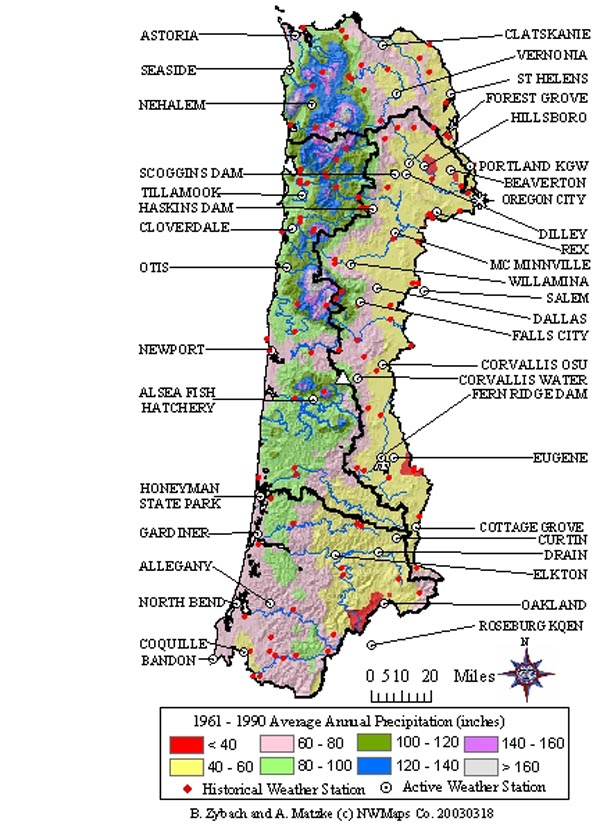
Map 1.04 Precipitation
of the Oregon Coast Range, 1961-1990.
Table 1.01 Oregon
Coast Range seasonal climate, 1961-1990.
|
Map 1.04
Location
|
"Killing
Frost" (28° F.)
|
Rain (7.0+
in.)
|
|
Annual Ave.
(in.)
|
Warm
(High Temp >65 F/mo)
|
Dry
(<3.0
in/mo)
|
|
Frost Free
Days
|
| |
First
|
Last
|
Fall
|
Winter
|
|
|
|
|
NORTH
|
|
|
|
|
|
|
First
|
Last
|
First
|
Last
|
Days
|
|
Astoria
|
Dec. 11
|
Mar. 3
|
Nov.
|
Feb.
|
66.42
|
July
|
Sep.
|
June
|
Sep.
|
283
|
|
Nehalem
|
|
|
Oct.
|
Apr.
|
121.74
|
|
|
|
July
|
Aug.
|
|
|
Oregon City
|
Dec. 6
|
Feb. 21
|
Dec.
|
Jan.
|
47.06
|
May
|
Sep.
|
May
|
Sep.
|
290
|
|
Portland KGW
|
Dec. 20
|
Feb. 3
|
Dec.
|
---
|
43.15
|
May
|
Sep.
|
Apr.
|
Sep.
|
320
|
|
Seaside
|
Nov. 3
|
Feb. 19
|
Nov.
|
Mar.
|
74.46
|
June
|
Sep.
|
June
|
Aug.
|
284
|
|
St. Helens
|
Nov. 27
|
Feb. 20
|
---
|
---
|
42.76
|
May
|
Oct.
|
Apr.
|
Sep.
|
|
|
EAST
|
|
|
|
|
|
|
|
|
|
|
|
|
|
|
Beaverton
|
Nov. 26
|
Mar. 9
|
---
|
---
|
39.77
|
May
|
Sep.
|
Apr.
|
Oct.
|
262
|
|
Corvallis
|
Nov. 26
|
Mar. 8
|
Dec.
|
---
|
42.67
|
May
|
Sep.
|
Apr.
|
Sep.
|
263
|
|
Corvallis W.B.
|
Nov. 26
|
Feb. 16
|
Nov.
|
Mar.
|
66.13
|
May
|
Sep.
|
May
|
Sep.
|
284
|
|
Cottage Grove
|
Nov. 10
|
Apr. 14
|
Nov.
|
Dec.
|
45.54
|
May
|
Oct.
|
May
|
Sep.
|
210
|
|
Dallas
|
Nov. 12
|
Mar. 23
|
Nov.
|
Jan.
|
48.42
|
May
|
Oct.
|
Apr.
|
Sep.
|
235
|
|
Dilley
|
|
|
Dec.
|
Jan.
|
44.2
|
|
|
|
Apr.
|
Sep.
|
|
|
Eugene WSO
|
|
|
Nov.
|
Jan.
|
49.25
|
May
|
Sep.
|
May
|
Sep.
|
259
|
|
Fern Ridge
|
Dec. 1
|
Feb. 19
|
Dec.
|
---
|
41.63
|
May
|
Sep.
|
Apr.
|
Oct.
|
286
|
|
Forest Grove
|
Nov. 12
|
Mar. 13
|
Dec.
|
Jan.
|
43.86
|
May
|
Oct.
|
Apr.
|
Sep.
|
245
|
|
Haskins
|
|
|
Nov.
|
Mar.
|
73.52
|
|
|
|
May
|
Sep.
|
|
|
Hillsboro
|
Nov. 16
|
Mar. 6
|
---
|
---
|
37.57
|
May
|
Sep.
|
Apr.
|
Oct.
|
255
|
|
N. Willamette
|
Nov. 14
|
Mar. 13
|
---
|
---
|
40.78
|
May
|
Sep.
|
Apr.
|
Oct.
|
246
|
|
Noti
|
|
|
Nov.
|
Mar.
|
60.65
|
|
|
|
May
|
Sep.
|
|
|
Rex
|
|
|
Dec.
|
---
|
41.37
|
|
|
|
Apr.
|
Sep.
|
|
|
Salem WSO
|
Nov. 2
|
Apr. 12
|
---
|
---
|
39.24
|
May
|
Sep.
|
Apr.
|
Oct.
|
204
|
|
Willamina
|
|
|
Nov.
|
Jan.
|
49.96
|
|
|
|
May
|
Sep.
|
|
|
WEST
|
|
|
|
|
|
|
|
|
|
|
|
|
|
|
Alsea
|
|
|
Nov.
|
Mar.
|
92
|
|
|
|
June
|
Aug.
|
|
|
Cloverdale
|
Dec. 18
|
Feb. 3
|
Nov.
|
Mar.
|
84.04
|
June
|
Sep.
|
July
|
Aug.
|
319
|
|
Newport
|
Dec. 19
|
Feb. 9
|
Nov.
|
Mar.
|
71.72
|
Aug.
|
Sep.
|
July
|
Sep.
|
314
|
|
Otis
|
Dec. 12
|
Feb. 6
|
Oct.
|
Mar.
|
97.27
|
June
|
Sep.
|
July
|
Aug.
|
310
|
|
Summit
|
|
|
Nov.
|
Mar.
|
68.86
|
|
|
|
June
|
Sep.
|
|
|
Tidewater
|
Dec. 12
|
Feb. 9
|
Nov.
|
Mar.
|
91.42
|
May
|
Oct.
|
June
|
Sep.
|
307
|
|
Tillamook
|
Nov. 8
|
Apr. 6
|
Oct.
|
Mar.
|
88.65
|
July
|
Sep.
|
July
|
Aug.
|
216
|
|
SOUTH
|
|
|
|
|
|
|
|
|
|
|
|
|
|
|
Bandon
|
Dec.15
|
Feb. 9
|
Nov.
|
Mar.
|
58.91
|
July
|
Sep.
|
May
|
Sep.
|
310
|
|
Coquille
|
Nov. 27
|
Feb. 10
|
|
|
|
|
|
|
|
|
|
|
292
|
|
Curtin
|
|
|
Nov.
|
Dec.
|
49.82
|
|
|
|
May
|
Sep.
|
|
|
Dora
|
Nov. 28
|
Feb. 20
|
|
|
|
|
|
|
|
|
|
|
283
|
|
Drain
|
Dec. 4
|
Mar. 9
|
Nov.
|
Jan.
|
46.17
|
May
|
Oct.
|
May
|
Sep.
|
270
|
|
Elkton
|
Dec. 17
|
Feb. 9
|
Nov.
|
Jan.
|
52.17
|
May
|
Oct.
|
May
|
Sep.
|
312
|
|
Honeyman
|
Dec. 19
|
Feb. 2
|
Nov.
|
Mar.
|
76.01
|
June
|
Sep.
|
June
|
Sep.
|
321
|
|
Idleyld
|
Nov. 10
|
Apr. 5
|
Nov.
|
Mar.
|
63.54
|
May
|
Oct.
|
May
|
Sep.
|
219
|
|
North Bend
|
Dec. 28
|
Jan. 29
|
Nov.
|
Mar.
|
63.48
|
July
|
Sep.
|
May
|
Sep.
|
334
|
|
Riddle
|
Dec. 11
|
Mar. 6
|
---
|
---
|
30.11
|
May
|
Oct.
|
Apr.
|
Oct.
|
281
|
|
Roseburg
|
Nov. 25
|
Mar. 1
|
---
|
---
|
32.44
|
May
|
Oct.
|
Apr.
|
Oct.
|
269
|
|
Sutherlin
|
|
|
---
|
---
|
41.13
|
|
|
|
May
|
Oct.
|
|
Burning seasons.An
analysis
of Table 1.01 shows a tendency toward four seasons in the Coast
Range: a) a warm, wet spring/early summer of
low
fire
hazard
due to air moisture, soil moisture, and fast growing trees
pulling massive amounts of water from the ground and transferring
it to the air through transpiration; b) a hot, dry late
summer/early fall with moisture stressed plants, dry soils,
desiccated
grasslands with high fire hazard potential,
especially on an east wind; c) heavy fall rains, knocking
desiccated
plants and leaves to the ground, filling rivers
and
creeks with water and fish; and d) killing frosts, desiccating
brackenfern prairies and woodland shrubs and trees, mostly
wet or frozen, but fires can spread on occasional east
winds, particularly through brakes, across unburned balds, brush
piles, and south-sloping berry patches.
Drought. The seasonal
droughts of the Pacific Northwest have been noted as one of
the primary factors favoring conifer forests over hardwood
forests in the region
(Franklin and Dyrness 1988). Many deciduous trees simply cannot
survive
long,
dry
summers without periodic irrigation (CITE). Graumlich (1987)
analyzed tree rings to arrive at a 300-year precipitation
pattern
that identified specific years (1717, 1721, 1739, 1839, 1899,
1929, and 1973) and
at least one decade per century (1790s, 1840s, 1860s, 1920s,
and
1930s) of prolonged regional drought. The annual events don't
seem to have a significant relationship to Coast Range fire
history, but
the prolonged droughts correlate closely with major forest
fire events (see Chapter 4).
3) Lightning
The entire Coast Range has remarkably few
lightning strikes or storms compared with
the remainder of the Pacific Northwest (Morris
1934; Kirkpatrick 1939: 28), and the first
reported lightning caused fire in the area
didn't occur until 1927 (Kirkpatrick 1939:
31). This is an important consideration
for this study because of the region's history
of forest fires and the existence of numerous
early historical prairies, meadows, brakes,
and balds in Alseya Valley. These landscape
features could have only been made and maintained
through regular Indian burning--no other
cause can be identified.
Passed over some beautiful farming lands low grumbling thunder heard at
a distance and I think this is the third time I have heard thunder in
the Territory as thunder and Lightening is varry rare From what cause
I cannot tell it may be possibly on account of the lowness of the clouds
which rest on the mountains and in fact on the earth even in the vallies
---James Clyman, June 4, 1845
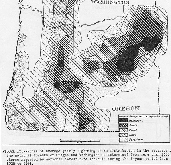
Map
1.05 Shows the locations of more than 2,600
lightning
storms recorded over a seven-year period in
Oregon, from 1925 to 1931. Note the pattern from
southwest, in the Biscuit fire area of the Klamath-Siskiyou
Mountains, to the northeast, along the crest
of the Cascade Range, thereby almost entirely
missing the Coast Range.
Map
1.06 Shows the locations of all lightning
strikes
recorded in Oregon over a five-year period, from
1992 to 1996. Note the remarkably few number
to strike in the Coast Range, although strikes
are common throughout the Klamath-Siskiyous,
and along the crest of the Cascade Range.
Map
1.07 . Shows the
location of 5,300 lightning fires
in Oregon mapped over a seven-year
period
from 1926 to 1931. Note the relatively
large number of fires in the
Klamath Siskiyous, and along the
crest
of the Cascade Range, and
the almost complete absence
of lightning caused fires during
the same time period in the
Coast Range.
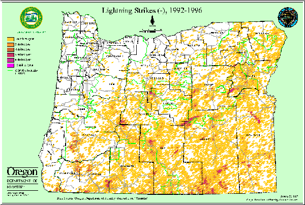
Map 1.06 Lightning
strikes in Oregon, 1992-1996.
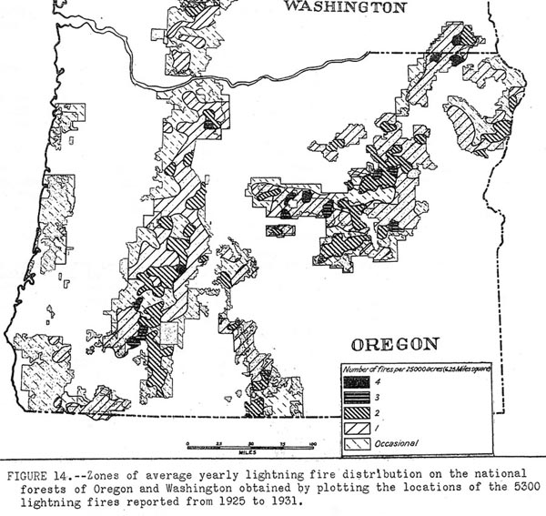
Map
1.07 Lightning fires in Oregon, 1925-1931.
4) Wind. The Columbus Day Storm of
1962 traveled due north from California to southern Washington,
including the Oregon Coast Range in its path. Over 11 billion
feet
of commercial timber were estimated to have been blown
down during
the course of this event (Lucia, c.1963: 50). In April,
1931,
a "dust storm" blew in from the northeast, spreading
wildfires
through coastal forests and farms (Grant, 1990: 7) and
causing a homefire at the southeastern base of Coffin
Butte to
blow
charred shingles "1/4 to 1/2 mile toward" the
southwest (Rohner and Rohner, 1993: 5). This storm was
noted by residents in
both Lincoln and Benton counties as a heavy east wind
bearing so
much red "alkali" dust from "eastern Oregon" that
it
caused the day to become dark and people to become "scared,
it
was so eerie" (ibid.: 5). .
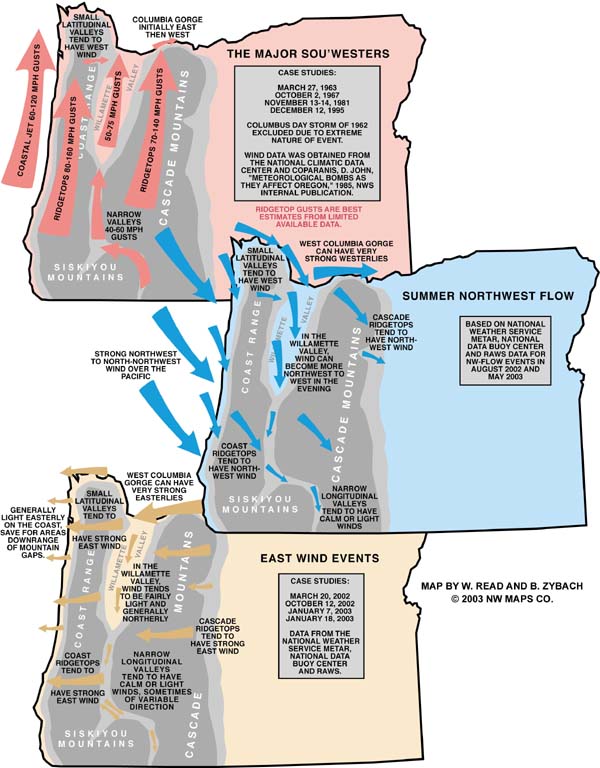
Map 1.08 Prevailing
wind patterns of the Oregon Coast Range.
D. Vegetation
and Fuel Patterns
The final side of the "fire behavior triangle," after
topography and weather, is fuel. For forested
areas, trees and shrubs form the
bulk of available fuel. For grasslands,
shrublands, and prairies, grasses,
ferns, and brush species comprise
most available fuel. Map
1.09 shows
the north-south distribution patterns
of the principal wildfire fuel types
of the Oregon Coast Range. Three types of
patterns dominate: along the coastal "fog-belt",
Sitka spruce, western hemlock, and
redcedar are the primary conifer
trees and red alder and bigleaf
maple are the major broadleaf species;
the eastern Coast Range is dominated
by the cities, towns, and farms
of the Willamette and Umpqua river
lowlands,
with native and exotic grasses,
ferns, white oak, black cottonwood,
and Oregon ash forming most of the
available fuel in unmanaged
areas; the remaining
central part of the Range is dominated
by some of the largest and fastest
growing mixed and "pure" stands
of Douglas-fir in the world, stretching
northward from the Middle Fork Coquille
and extending through
the wettest and steepest lands of
the Coast Range in an unbroken conifer
forest that reaches completely to
the Columbia River, straddling all
four subregions and connecting them
all together with a nearly unbroken
shifting mosaic of some of the largest
and fastest growing conifer
trees ever measured. These are
also the ingredients for
some of the largest and most destructive
forest wildfires in history--massive
amounts of living and dead, pitchy,
conifer fuels, grasses, and
ferns per acre for tens of thousands
of contiguous acres; an unbroken,
rolling topography that stretches
from north to south the entire length
of the region; and seasonal droughts,
often accompanied by low humidity,
hot temperatures, and dry, east
winds.
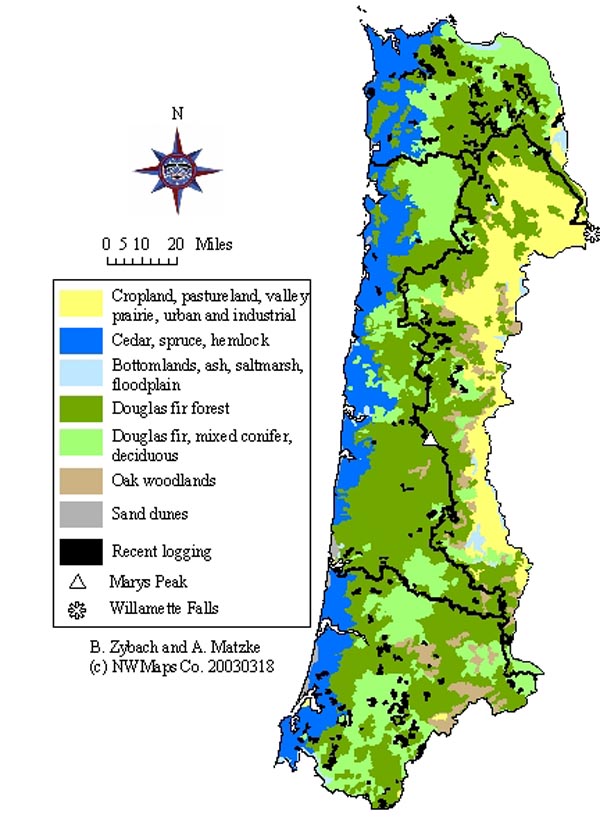
Map 1.09 Native
vegetation patterns of the Oregon Coast Range.
The three principal "fire triangle" components
of wildfire and controlled burns are fuel, weather, and topography. All
else that is needed
is a source of ignition. The Oregon Coast Range has
abundant forest and grassland fuel, regular seasonal droughts and wind
patterns that are ideal
for landscape-scale burning practices and wildfire events;
a long history of both, and a varied topography that includes large expanses
each of
flat, sloping, steep, and heavily dissected terrain.
Every hour, day and year people start and/or maintain thousands of fires
in a systematic arrangement
that borders and crosses the entire Coast Range landscape;
typically in patterns that reflect the spatial demographics of the population
at any
given point in time.
From
the late 1400s until the late 1840s, and for a period
of time likely extending more than 10,000 years
before then, the Coast Range
was populated by a wide variety and large number of
native
American Indian cultures, all
of whom undoubtedly used fire skillfully on a daily
and constant basis. The history of forest wildfires
for this
period is incomplete, but a
great deal can be inferred
by the trails systems, expansive
prairies, oak savannah, wild berry patches, and other "cultural
legacy" left behind by these people.
From 1849 through 1951,
a series of catastrophic forest fires took place in the Coast Range
that transformed
100s
of thousands of forested acres to charred snags. Wildlife habitat
was
often burned at a rate of tens of thousands of acres a day during
the
course of these Great Fires. From 1952 until 2003, only a few Coast
Range
fires occurred that could be termed "large", and none
approached 100,000 acres in size. This thesis addresses
the question of whether the use of fire across the landscape by Indian
people over the
span of 350+ years prior to 1849, had any relationship
to a subsequent series of catastrophic forest fires, that lasted until
1951. Specifically,
were their differences or similarities in the seasonal
timing of large scale fires? Common or differing causes and locations
of ignition? Common
or differing burn boundaries?
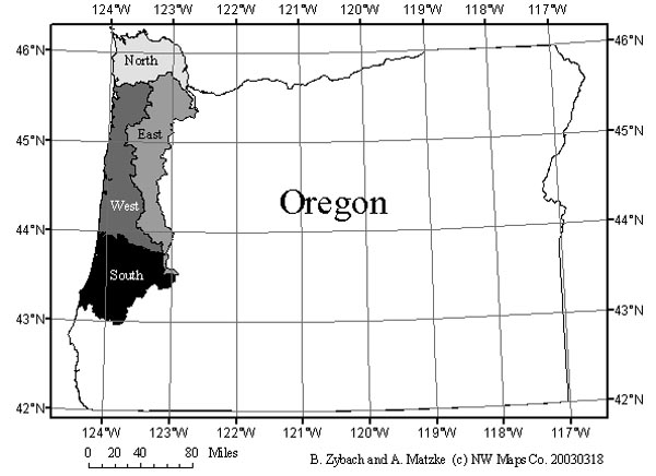
To
better answer this question,
the entire region was divided
into four subregions: North,
East, West, and South
for comparison. Each has distinct drainage
patterns, weather patterns,
vegetation patterns, and human
use and settlement
patterns; both in precontact
and historical time.
North
is dominated by the Columbia River, the Willamette
River from the Falls to its mouth, the heavily
dissected terrain of the Nehalem River basin, and
Clatsop
Spit. It is mostly forested with conifers: spruce,
hemlock, cedar
and shorepine on the western edge, and Douglas-fir
dominated forests throughout the remainder, with
oak appearing in groves
and scatterings as far west
as Oak Point, at Fanny's Bottom, an old Klaskani
townsite. Annual spring floods,
caused by the melting snows of Rocky Mountain and
Cascade Range glaciers
and snowpack, regularly inundate and erode the banks
of the Columbia.
Daily tides reach the entire northern length of the
Coast Range,
from Astoria to Portland, and extend along its entire
western, Pacific
ocean, boundary. Its
southern boundary is dominated by Saddle Mountain,
one of the wettest
areas of the Coast Range; its eastern boundary is
dominated by Sauvies
Island, one of the driest and most regularly flooded
areas of the Range.
East
is dominated by the floodplains and upland prairies
of the Willamette River, with oak, cottonwood,
willow, and other deciduous trees being the most
widespread
species. Douglas-fir and some true fir forests dominate
the western peaks
and valleys of the subregion; which are
entirely drained by a north-south series of west
to east flowing rivers that empty into the Willamette
River;
which forms the eastern boundary of the region. Elevation
ranges from
the grassy balds of Marys Peak, at over 4,000 feet
elevation, to
Willamette Falls, whose pool is not too much
above tidewater. East is the driest, flattest, and
most generally low elevation (below
400 feet) of the subregions; it also has the least
amount of conifer
forest and some
of the poorest soils and weather for Douglas-fir
and hemlock.
West
is dominated by the Pacific Ocean along its
entire
western boundary; Marys Peak along its common
ridgeline boundary with the eastern subregion; Tillamook
Bay
to the north and Table Mountain to the south. Tideland
is usually either
rocky or sandy, often lined with a thin strip of shorepine, usually
only a few hundred yards wide and rarely a mile
wide.
To the immediate east the shorepine is another north-south
strip
of spruce-hemlock forest, that extends as far inland as the fogbelt
climate it requires for
dominance. Inland from the coastal fogbelt
forest, and extending throughout
the remainder
of the subregion, is a great north-south swath of
Douglas-fir forest
that is the setting for some of the fastest growing conifer forests
in
the world and some of the largest and most memorable
forest fires
in history. The highest peaks and ridgelines are
often characterized
by grassy balds,
brackenfern prairies, and occasional stands
of true fir trees.
South
is defined by the mainstem Umpqua River
Valley,
the
coastal cranberry bogs, and the Port Orford
and myrtlewood forests of the Coos and Coquille
river
basins.
Coos Bay was the scene of some of the first
extensive clearcutting and
sawmilling in the Coast Range, when those
industries
were undertaken
to help satisfy the rebuilding of San Francisco
and
the expansion of region-wide goldmining in the early
1850s.
In 1868, the Coos Fire consumed more than 100,000
acres of prime timberland in just a few
weeks time. South is dryer, warmer, and lower in
elevation than West
or North, but
wetter, cooler, and generally higher in
elevation
that East. The
Umpqua Valley area was inhabited by Kalapuyan
people
who maintained an oak
savannah similar to the savannah maintained
by other Kalapuyans in the
Willamette Valley. Black oak and tanoak are
more
common in the southern region, though,
while white
oak is the most widespread tree species
in the East; and no species of oak is common
throughout most of
the western and northern subregions.