APPENDIX H.
"ALSEYA VALLEY" PRAIRIE RELICTS: APRIL 14, 2003
[Note to Committee: these jpegs are made to 8" X 10" size for HTML formatting, but will be cropped 2 to 4 per page, as in Fig. 3.06, for the library draft.]
This appendix provides photographic evidence of the "cultural legacy" resulting from precontact Indian burning practices in Alsea Valley (see Map 2.13 and Appendix D). These pictures were taken the day following a series of major lightning storms and thunder showers throughout the local area. In addition to recording persistent vegetation patterns of grasslands and forests that date to precontact time, they also provide evidence of how weather events may have changed river uses during those times. The rock shelf that forms the foot crossing on the old Indian Trail could probably still be safely used by healthy adults--especially with the aid of a crossing rope, log, or weir foot bridge--even in times of heavy rains and swollen streams. Nathaniel, the kayaker at Clemens Park, demonstrates the safety and ease in which small canoes could be used on the river, following major rainfall events.
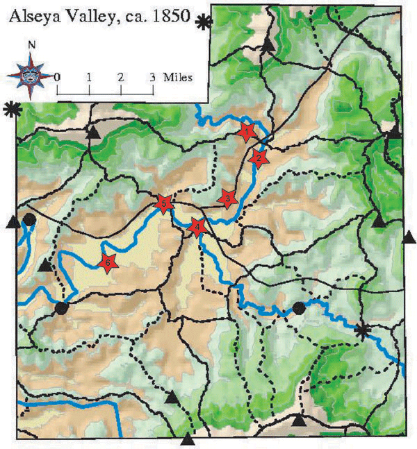
Map H.01 is an index of six stops made along the "Indian Trail to Tidewater" route mapped in 1856 (see Map 2.11).
Each of the six numbered stars represents a series of 1-6 photographs of that location taken on April 14, 2003. The vegetation pattern shown on Map H.01 is generally accurate for the 1800-1850 time period, according to GLO survey records (Appendix D). Each of these locations was plotted, or nearly so, in advance of the photographic survey as suspected major townsites and/or camping grounds.
Map H.01 Index to "Alseya Valley" prairie relicts, April 14, 2003 (Zybach, Gruen, and Matzke 2003).
1. North Fork prairie campground and Alsea River crossing
This prairie relict is located adjacent to the only river crossing on the Indian Trail from Marys River, in the Willamette Valley, to Tidewater, a major Alsi townsite and head of tidal navigation. This crossing is easy to locate on Map H.01; it is just southeast of the North Fork prairie star, #1. The legal description is Tsp. 13 S., Rng. 7 W., Sec. 28. It is located near, according to local landowners near the crossing, the original Rubles mill site. Note the logs in the river: there was enough water this day to use a canoe upstream from the crossing, but downstream was too shallow and rapid. A good day to transport firewood downstream, though.
2. Clemens Park campground and canoe launch
Nathaniel shows the possibility of river travel, the day after a mjor rainstorm, near Clemens Park. The picnic spot on the north shore indicates the ease in which canoes could be put in and out of the river at this location. Tsp. 13 S., Rng. 7 W., Sec. 32.
3. Honey Grove Road riparian meadow, prairie, and river rock
Riparian meadows, an open grown old-growth Douglas-fir, and a grassy riparian meadow indicate precontact land use patterns at this location. The ready availability of river rock for tools such as hammers, wedges, pestles, missiles, etc., is shown by this easily accessed rock bar. Tsp.14 S., Rng. 7 W., Sec. 5.
4. Alsea Forks prairie landmark, oak grove and townsite
Does this hill have a name? It has to be a local landmark, and most certainly must have been a landmark in precontact time as well. Lots of archaeological indicators near these locations that this likely may have been a major townsite in precontact time. The strategic location by both international foot and canoe traffic for trade purposes, and the ready availability of a wide range of local seasonal food sources, and the protective location of the valley, deep within the Coast Range are all likely indicators of long periods of past daily and seasonal use by relatively large numbers of people. Historical records say that hundreds of Alsi, Klickitat, Siletz, and Kalapuya Indians would gather near this location for weeks at a time for purposes of gambling, horse racing, etc. Similar gatherings must have occurred during periods of root harvests, fishing, berry picking, nut harvesting, and camas digging. Local firewood use during those times must have been enormous. Tsp. 14 S., Rng. 7 W., Sec. 6.
5. Mill Creek homesite, campground, and canoe launch
This is near the homesite of "Old Billy", apparently an Alsi Indian who lived here in the 1850s and perhaps longer (Hathorn 1856b: 262; Rycraft ca.1922). This was probably a good fishing location, was close to town, easy canoe access, and may have been a major campground, especially after the community of Alsea was established. Tsp. 14 S., Rng. 8 W., Sec. 2.
6. The Narrows prairie townsite, campground, and river crossing
This is near a confirmed archaeological site; an old-growth oak and filbert orchard campground near a river crossing and fishing spot. The narrows may have been a secondary townsite in Alseya Valley before 1780s: one resident of the 1870s reported, "In 1880 there were not more than 300 whites in the valley and I have seen as many as 1,000 Indians at one time. There was an Indian camp ground at the "narrows" about three miles below Alsea and the Indians used to come and go" (Phinney 2000: 165). Tsp. 14 S., Rng. 8 W., Sec. 8.