Table of Contents
Introduction: The view from Buck Peak,
1853-1914
History of the rectangular survey, 1784-1850
General Land Office survey methods in Oregon,
1851-1910
Tsp. 13 S., Rng 7 W. (13-7): Indian Trail
to Alseya
Tsp. 13 S., Rng. 8 W. (13-8): Grass Mountain
Tsp. 14 S., Rng. 7 W. (14-7): Inmon Mill
Tsp. 14 S., Rng. 8 W. (14-8): Indian Trail
to Tidewater
Tsp. 15 S., Rng. 7 W. (15-7): Prairie
Mountain
Tsp. 15 S.,
Rng. 8 W. (15-8): Lobster River
Introduction: The view from Buck
Peak, 1853-1914
This appendix is intended to serve a dual purpose.
First, it provides an
overview of General Land
Office (GLO) survey history
and methods; a key source
of materials used to research
this thesis. Second, it
provides an indexed sampling
of the types of information
gathered by GLO surveyors
as they surveyed Alsea
Valley, in Benton County,
Oregon, and compares
it with information gathered
and recorded by an historian
and a timber cruiser
who described portions
of the same area during
the same general period
of time. All of the
excerpts are indexed
by legal description,
as assigned by the original
land surveyors and used
to now.
The cited surveyors are
the same as listed in Table 2.02.
The Alsea Valley area
is located on Map
2.01, and shown on Maps 2.12 and
2.13. The historian
is David D. Fagan (1885),
who is cited throughout
the thesis. The timber
cruiser is J. H. Bagley
(1915), whose maps and
survey notes are typified
by Map 2.05. This
appendix is
indexed by Tsp. and Rng.
(see Map
2.01) and by square-mile sections (see
Map 2.02). Entries are arranged chronologically, except when noted.
This appendix contains a large number of representative
surveyors' field notes
on fires, reforestation,
species location, and
Indian trails. In
keeping with the focus
of this thesis, I have
left out most references
to compass bearings, distances,
and other measures of
little interest
to most non-surveyors,
as they tend to detract from the narrative flow
of the field notes. Likewise,
I have left most references
to topography,
slope, stream crossing
locations and stream widths
out of the narrative because
this information changes
from time to time and/or
is readily available from
other sources. These excerpts
are arranged by legal
description and indexed
by location, using Map
D.01. To
get an idea as to the
differences in writing style
and perspective
provided by the different
observers, a sample excerpt
follows in which each
observer is looking over
Alsea Valley from a vantage
point on--or very near--the
valley's eastern boundary,
Buck Peak (see Map D.01):
General Land Office survey methods,
1851-1910
Detailed survey instructions were developed following the
act of September 27, 1850 and subsequently issued
for the survey of Oregon in 1851 (Moore 1851).
These instructions were changed slightly and formalized
for the entire US in 1855 (Moore 1855). These latter
instructions remained in effect until after 1910,
with the result that the entire Pacific Northwest
was surveyed by a single prescribed method using
only one set of instructions, with only
slight modifications from time to time.
By 1855, 12 contract surveyors were working in
Oregon and had completed surveys of 1,450 of 1,800
total Donation Land Claims
(DLCs) (see Map D.02), in addition to townships and township subdivisions.
By 1856, more than 836,000 acres had been surveyed,
despite southern Oregon "Indian
hostilities", "cloudy weather", and "the mines" that
had "hindered progress" on the project (Prosch 1907: 196-197).
(The reference to "the mines" was to the lure of instant wealth
that had drawn single men and whole families from their homes and jobs
in western Oregon to the gold fields of northern California and southwest
Oregon, beginning in 1848 (Haskin 1948; Carey 1971: 359, 478-479, 654)
and continuing through the Civil War).
Map
D.02 Tsp. 14 S., Rng. 8 W., GLO Donation Land Claim (DLC) surveys,
1856.
The GLO rectangular survey system is based on an
systematic arrangement of square miles, or "sections". Each section
was located with four corners one mile distance
from one another, each marked with four "bearing trees". Bearing
trees were established in quadrants: one in each
of the four adjacent sections that shared a corner.
Halfway between each section corner a "1/4 sec." corner was established
with two bearing trees; one on either side of the
line. Therefore, each section corner and 1/4 sec.
corner located bearing trees in each adjacent
section. A section had four corners and four 1/4
sec. corners, so for each forested square mile
a total of eight bearing trees could be expected
to be established. In instances where trees were
absent or too small to be used for surveys,
other methods were used to mark corners. Bearing
trees were carefully marked, identified as
to species and general condition, measured
for diameter, and located by distance and compass
bearing from each corner. They are protected
by strict laws and are the basis for all property
and subsequent tax lot descriptions and subdivisions
from 1851 to now. When original bearing trees have
been destroyed, or are unable to be relocated
due to surveyor error or other cause, they are
replaced with new bearing trees, so a continuous
record of all survey corners and trees is kept
from the time of the original survey (1851-1910) until now.
An exact square mile contains 640 acres. Due to
the curvature of the earth and occasional surveyor
error, a section rarely contains exactly 640 acres.
For the same reasons, or in instances where
a survey intersects the shoreline of the ocean,
a large lake, or wide river, townships sometimes
contain less than 36 sections. In such cases, the
numbering pattern remains the same as if the township
were whole (see Map 2.02). DLCs
established by December
1, 1850 could be as many
as 640 acres in size;
320 acres for "white
settler" or "American half-breed" citizens
at least 18 years of age (Carey 1971: 253), and
the same amount for his wife, "to be held by her in her own right" (ibid.:
482). This is one of the first federal laws extending
equal rights to married women who, by Oregon law
at that time, could be as young as 12 years old.
Single persons (men and widows older than 18)
could claim 320 acres. From December 2, 1850
until 1855, a man and wife could claim 320 acres
and a single person 160 acres. All of the
DLCs shown on Map D.02 were claimed after 1850,
so none are larger than 320 acres. Their relative size indicates whether
the claim was made by a single male or a man and
wife. DLC surveys were conducted in the same manner
as rectangular subdivisions, and were tied into
the subdivisions by measure and description, but
used a different method for establishing bearing
trees at each corner. Because DLCs often had six,
eight, or more corners, and because they included
trees well-within the boundaries of section lines,
these surveys provide us with far more exacting
information--particularly near the center of the
sections in which they are located--than surveys
of sections that do not include DLCs (see Maps
3.03 and
3.04).
Map D.03 shows a portion of the GLO
map of T. 15 S., R. 7 W., illustrating corrections
made in 1940 to the survey of 1897. Note the rectangular
sections of the original survey have now been
replaced with trapezoids and octagons. This map
demonstrates one method by which survey error
can be corrected, while still using the original
bearing trees. In extreme cases, initial
results were voided and entirely new surveys
undertaken. Speculation regarding the cause
of error in this township is that the "surveyor was lazy" and
simply took the "easiest route between corners, rather than the straightest" (Mardis
2002: personal communication). Other survey errors
noted in the study area were usually noted in the
field and corrected at the time (e.g., Gesner
1891a: 244-245; Mercer 1878: 164). Some errors
were less troublesome and left uncorrected, as
when Collier (1893: 185) reported the diameters
of bearing trees had not changed in the 40 years
since they were first established and, in one
instance, had even decreased an inch in size
over a 15 year period!
Map
D.03 Tsp. 15 S., Rng. 7 W., GLO survey error
with corrections, 1897-1940.
In addition to
surveyor error, fraud and statistical bias have been other causes
for concern regarding the quality and usefulness
of GLO data. Fraud is a minor problem, although
not unknown, with GLO surveys. A well known case
that took place in California from 1873 to 1885,
the so-called "Benson
Frauds" (Stewart 1935:
66), has helped cause some researchers to conclude
the practice was far more prevalent than it was.
In my own experience, I have
examined hundreds of
GLO maps and thousands of pages of GLO field notes
for Oregon and southwest Washington during the
past 30 years (e.g., Braman 1987; Zybach 1992;
Zybach 1999) and uncovered only a few minor
instances of possible dishonesty: the Sharp (1897)
and Gesner (1891a) surveys used in this appendix
are about as close as any, and they tend to represent
sloppy workmanship rather than outright fraud.
In most cases, such poor quality work is usually
(as in the instance illustrated by Map D.03)
compensated or corrected by others at some later
point in time, and has little bearing on the overall
quality of the surveys (see Bourdo 1956: 760).
The same holds true for surveyor bias. Statistical
tests have demonstrated that, while bias certainly
exists, it is of little consequence when considered
in context of the entire body of work or when
considering broad spatial scales (Bourdo
1956:760-767; Schulte and Mladenoff 2001: 7; Whitney
and DeCant 2001: 155).
Tsp.
13 S., Rng 7 W. (13-7): Indian Trail to Alseya
General
Description
[Hathorn 1856: 332] The
quality of soil in this
fractional township along
the river is 1st rate;
the hilly portions 2nd
rate; the timber is principally
fir; the open portions
are covered with hazel
and fern. The unsurveyed
portions of the township
are too mountainous
for settlement or cultivation.
|
Sec.
1
|
[N mile between 1 and 6] Top
of ridge
. . . Top
of ridge
. . . A
maple,
6 ins.
. . . A maple, 4 ins. . . . Wells Creek . . . Indian Trail to the
Alseya, course
SW. Foot
of hill,
begin
to ascend
. . . Land,
mountainous
and unfit
for cultivation.
Fir, timber (Gordon and Preston 1854: 275)
|
|
|
[N
mile
between 1 and 6] Top
of
spur . . . Old
corner A fir,
4 ins. . . . marks
overgrown. A fir,
8 ins. . . . marks overgrown. A fir, 18 ins. . . . marks
overgrown. A yew,
12 ins. .
. . marks overgrown.
Top of ridge .
. . Ravine . . . Top
of ridge . . . Bottom of ravine
. . . Top of ridge
. . . Bottom of ravine
. . . Top of ridge
. . . A fir, 12 ins. . . . A fir, 12 ins. . . . the bearing
trees have probably
rotted and slid
down the hill .
. . Top of a ridge . . . Wells
Creek . . . Road from Philomath to Alsea . . . Stream .
. . Indian
trail, from Willamette
Valley to Alsea,
course SW. and
NE. . . . A red
fir, 4 ins. .
. . A red fir, 18 ins. . . . A red fir, 5 ins. . . . A red
fir,
6 ins. . . . Heavily
timbered with fir,
cedar and hemlock,
and covered with a dense undergrowth
of vine maple, salal, rhododendron and devil's war club
(Collier
1892: 339-341) |
Tsp. 13
S., Rng. 8 W. (13-8): Grass Mountain
General
Description
[Hathorn
1856: 412] This township is all mountainous. Timber
principally fir
and much of it burnt;
none but sec. 36 deemed fit for settlement. There are some burnt
openings covered with fern, but no grass land
except near the summit
of a very high mountain,
two miles from the west line and two from the south line of the township.
On this there is probably a sec.
of grass.
[Collier,
September 23, 1891: 407] The
greater portion of this township is rough, mountainous
and broken. There is much rich bottom land along the
Alsea and it's tributaries, which rises in the
township. The entire township is covered with heavy
timber and dense undergrowth, which has been cleared
away in a few spots by the settlers. There
are a number of settlers in the township. It should be subdivided.
[Sharp,
September 21, 1897: 454-455] This township contains but one variety
of land, rough, mountainous and broken. The
soil is of one general character and about 3rd rate, productive of
much vegetation, vines and timber, owing to the heavy rainfall. It
is entirely
without grass except in a few open glades on Grass Mountain in about
the center of the township. Extensive fires raged over the greater
part of this township
about forty years ago leaving much dead timber now intermingled with
a new growth, in many places being thickets. Much valuable timber
exists upon this
township, but large quantities have been destroyed by forest fires
. . . Grass Mountain, the highest land in the township, is located
nearly in the center and
from it the water flows north, south, east and west, eventually all
in the Alsea River. The township is entirely without settlement, the
petitioners
praying for the survey are located upon sec. 36 of this township
. . . But little, if any, of this township is suitable for settlement.
(Sharp, September
21, 1897: 454-455)
Map
D.04 Grass Mountain balds and trails, 1971.
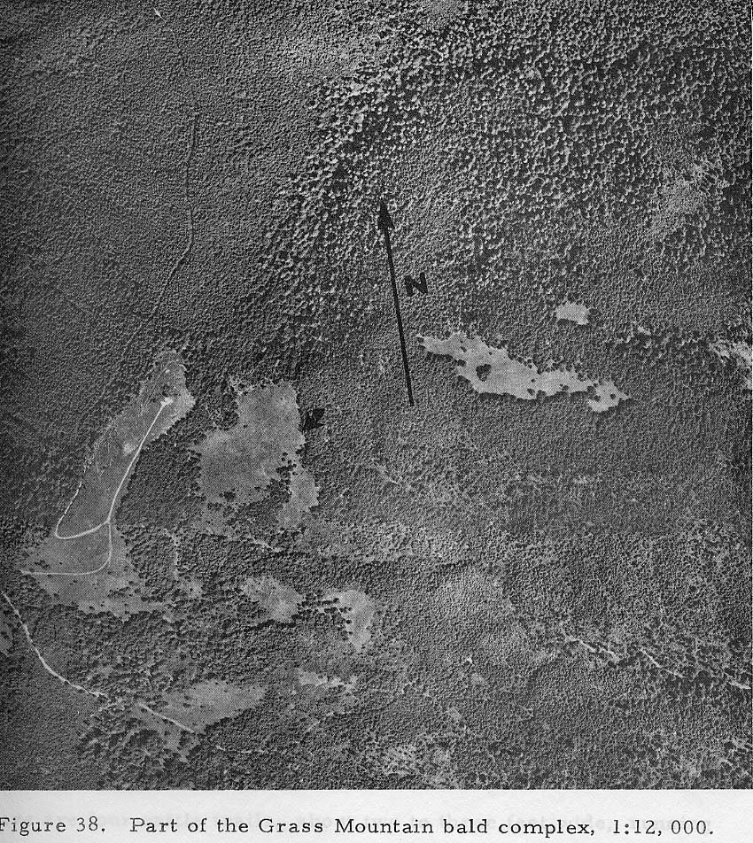
Fig. D.01 Aerial photo
of Grass Mountain balds,
1966.
[Compare the persistent
patterns of trails and
vegetation shown on
this aerial photograph
and on Map D.04, with
GLO surveys of the
same area, performed from
1856-1897.]
Tsp. 14
S., Rng. 7 W. (14-7): Inmon Mill
General Description
[Hathorn, c. June 15, 1856: 164] The
quality of the soil in this fractional township, along the Alseya and
its branches, is excellent and produces abundance of grass. The uplands
are 2nd
rate soil and covered with a very heavy growth of fern. The timber is
principally fir.
[Collier, April 24, 1893: 175] A
large part seems to have its timber deadened, offering excellent range for
cattle . . . the snow lay just south of our line during the time of the survey.
. . There are several settlers scattered through different parts. It should be
subdivided.
[Collier May 12, 1893: 228] 43
miles, 77 chs. and 15 lks. of these subdivision lines run over mountainous
lands or through timber. . . The usual vegetation of the Coast Range grows
strongly everywhere. Wild grass and pea vine grows thick where other growths
have been killed. Most of the openings are taken by a rank growth of fern.
The whole has been covered by heavy fir, cedar and hemlock forests which
has
been deadened by fire on about half the area and the slopes exposed afford
excellent range for cattle and sheep.
|
Sec. 1
|
[S mile between 1 and 6] A
fir, 24 ins. . . . A fir, 18 ins.
. . . A fir, 36 ins. . . . Land,
all rough mountains. . . Timber,
fir, cedar, etc. Undergrowth, hazel,
fern, fir, etc.
The west 3 1/2 miles of this line
is rough mountains of the Coast
Range . . . Top of ridge . . . A
fir, 28 ins. . . . A fir, 18 ins.
. . . A fir , 30 ins.
. . . A fir, 30 ins. . . . A fir
40 ins. . . . A fir, 60 ins. . .
. A fir, 14 ins.. . . . All rough
mountains. . . Timber, fir and cedar,
principally dead. Undergrowth, hazel,
fern, briars, etc. (Webster October
12, 1853: 98).
|
|
|
[W mile between 1 and 36] A
sink of earth about 10 feet deep
and 10 wide. . . . Summit of ridge. . . A fir 36 ins. . . .A fir 12
ins. . . Summit of ridge. . . A cedar
30 ins. . . .
A fir 30 ins. . . Timber, fir cedar
and hemlock. Undergrowth, hemlock, fern and salal (Hathorn 1856: 151).
|
|
Sec. 2
|
[W mile between 2 and 35] Summit
of mountain, overlooking the Alseya Valley, course N. and S. . . A
fir 24 ins. . . . A fir, 12 ins. . . A fir, 24 . . . A Maple, 20 ins.
. . A hemlock,
20 ins. . . . Land, very rough and west slope of mountain very steep
and rocky (Hathorn 1856: 151)
|
|
|
[S mile between 1 and 2] Along
east slope in heavy forest of fir and hemlock. Top of high timbered
ridge . . . Thence along steep West slope in heavy timber and thick
salal . . . A fir,
24 ins. . . . A fir, 48 ins. . . . Spur from Buck Peak . . . Fir, 60
ins. . . . Ravine . . . Spur . . . Heavily timbered with fir, cedar,
and hemlock and
covered with dense undergrowth of salal (Collier 1893: 191)
|
|
Bagley 1915
|
Yellow or bastard fir is just fair
in quality, is low in clears and there is a large amount of defect. Red fir
is young and thrifty but low in clears. Hemlock is young, thrifty and low in
clears. Cedar is defective and good for posts only . . . A ground fire has
been over nearly all of the section years ago and while it did not kill any
great amount of timber at the time, a large amount is beginning to show
defect. The fire risk is nominal.
|
|
Sec. 3
|
[3/34 W] A
fir, 40 ins. . . . Summit of narrow ridge . . . A fir, 36 ins. . .
.A fir, 24 ins. . . A cedar, 30 ins. . . .Summit of a ridge . . . A
fir, 40 ins. . . .A
dogwood 12 ins. . . .Timber, fir, cedar and hemlock. Undergrowth, salal
and fern (Hathorn 1856: 152)
|
|
|
[2/3 S] A
maple, 20 ins. . . . A hemlock, 20 ins. . . . Descend gradually through heavy
timber. . . Ascend gradually . . . A fir, 36 ins. . . . A fir, 18 ins. . .
.A fir, 18 ins. . . . Ascend rapidly. Top of ridge . . .descend sharply . . .
Heavily timbered with fir, cedar and hemlock, with undergrowth of salal, vine
maple and arrowwood (Collier 1893: 196)
|
|
Sec. 4
|
[W mile between 4 and 33] A
fir, 36 ins. . . .Summit of ridge . . . A cedar, 48 ins. . . . A vine
maple, 9 ins. . . . A fir, 12 ins. . . . A fir, 15 ins. . . .Timber,
fir, cedar and
hemlock. Undergrowth, vine maple, hazel and fern (Hathorn
1856: 152-153)
|
|
|
[S mile between 3 and 4] A
fir, 40 ins. . . .mkd. with
surveyor’s guage but mark mostly burnt off . . .
A dogwood, 12 ins. . . .now fallen,
mkd. but marks nearly rotted away
[exact species and sizes recorded by Hathorn 1856, pg. 152: killed shortly
thereafter?]. . . A fir, 5 ins.
. . . Descend sharply. Enter bottom.
Fence
. . . enter meadow . . . Mr.
Hutchin's house . . .
about 10 chs. dist. Mr. Trout's
house . . . about 25 chs. dist.
. . . leave meadow and clearing,
enter timber and brush . .
. Leave bottom; ascend along broken
N. slope . . . A maple, 8 ins. . . .
A maple, 5 iins. . . . Top
of ridge . . . Land . . .
bottom . . . partially cleared
and seeded to grass . . . Heavily
timbered with fir, cedar and hemlock
and covered with dense undergrowth
of same and vine maple, arrowwood,
dogwood, salal and maple (Collier
1893: 207-208)
|
|
Boise 1893
|
Mr. Boise has small clearing and
cabin in SW 1/4 (Collier 1893: 229)
|
|
Hutchins 1893
|
Mr. Hutchins has house, barn and 7
or 8 acres in cultivation or meadow in sec. 4, NE 1/4 (Collier 1893: 229)
|
|
Trout 1893
|
Mr. Trout has house and barn and
some land in cultivation in NE 1/4 (Collier 1893: 229)
|
|
Bagley 1915
|
Yellow fir is sound and A#1 grade.
Red fir is sound and a fair grade. Cedar is sound and a good quality. There
is some fire damage as shown in red on the plat [84 acres]. The fire risk
is ordinary one.
|
|
Sec.
5
|
[5/32
W] Enter prairie, course N. and SW. . . . A fir, 30 ins. . . . A
fir, 5 ins. . . .
Enter river bottom . . . East half timbered same as last mile
[4/33 W]; west half prairie (Hathorn 1856: 153)
|
|
|
[4/5 S] A
cedar, 15 ins. . . . A cedar 7 ins. . . . A cedar, 16 ins. . .
. A cedar 14 ins. . . A red fir, 24 ins. . . . South Fork of Alsea
River . . . A fir, 20
ins. . . . An alder, 20 ins. . . . A fir, 14 ins. . . A fir, 12
ins. . . . A fir, 30 ins. . . . A fir, 36 ins. . . . Timber, fir,
cedar, hemlock alder,
with heavy underbrush (Mercer 1878: 164-165)
|
|
Bagley 1915
|
Yellow fir is sound and a good
quality. Red fir and cedar is a fair quality of timber. There is some fire
damage as shown in red on the plat. The fire risk is ordinary one.
|
|
Sec. 6
|
[W mile between 6 and 31: Error?] Leave
prairie and enter timber. . . .
Enter North Fork of Alseya River. Leave same . . . Enter prairie . .
. Jacob Holgate’s house . . . Trail . . . Enter
thicket . . . Leave same . . . Leave bottom and commence ascending
hill . . . Enter timber . . . A maple, 10 ins. . . . A maple, 4 ins.
. . . Enter fern
prairie . . . .A maple 20 ins. . . . A maple 20 ins. . . . Land hilly.
Timber, principally fir and maple. The high prairie is covered with
a thick coat of
fern from 6 to 8 ft. high. (Hathorn, June 9, 1856:153-154)
|
|
|
[W mile between 6 and 31: Error?] Trail
. . . Enter alder thicket . . . Leave same . . . Enter timber . . .
Leave timber and enter fir opening . . . A fir, 40 in. . . . 285 lks.
. . . An
alder, 10 in. . . . 218 lks. . . . An alder, 9 in. . . 135 lks. . .
. An alder, 10 in. . . . 77 lks. . . . No tre convenient NE. Land hilly;
about
half covered with fir and maple; balance open and all the high portions
are covered with a large growth of fern (Hathorn, June 28, 1856: 325-326)
|
|
|
[S mile between 5 and 6] Leave
prairie and enter timber . . . A dogwood, 10 ins. . . . A vine maple,
10 ins. . . . Summit of ridge . . . About one-fourth level land . .
. Timbered with
fir. Under growth maple, hazel, and fern (Hathorn 1856:
161-162)
|
|
Holgate 1856
|
[#7879: 319.5 A., beginning at NW corner in 13-7-31] A
dogwood, 6 ins. . . . A fir, 10 ins. . . . Enter prairie . . . Enter
thicket . . .Enter field . . . Enter Holgate and William’s house. Leave
same. Leave field . . . Trail . . . Enter thicket, Enter prairie, Enter
timber . .
.Enter prairie . . . A fir, 40 ins. . . . 1028 lks. A fir, 40 ins.
. . . 1080 lks. . . . An oak, 12 ins. . . . 233 lks. An oak, 12 ins.
. . .177 lks.
. . . Summit of ridge . . . Enter timber . . .Enter North Fork of Alseya
River. Leave same . . . Enter same Leave same . . . A crab apple, 12
ins. . . .An ash, 30 ins. . . . An ash, 12 ins. . . . A fir, 60 [ins.?]
wide . . .
190 lks. . . . Enter prairie or openings . . . An oak, 30 ins. . .
.A fir, 36 ins. . . . 820 lks. . . . Leave prairie and enter timber
. . . Enter North
Fork of Alseya River. Leave same . . . Enter prairie . . . Trail .
. . Enter thicket . . . Enter prairie . . . Leave prairie and enter
timber . . . To
beginning cor. Land about half level prairie and timbered bottoms.
. . Timber fir and maple principally. About ten acres in cultivation.
Buildings
2nd rate log. (Hathorn 1856a: 469-471)
|
|
Bagley 1915
|
Yellow fir is a good quality of
timber. Red fir and cedar are a coarse grade of timber . . . There has been
no recent fire damage and the fire risk is ordinary. The balance of the
section is open grass land and farming land.
|
|
Sec. 7
|
[N mile between 7 and 8] .
. Enter openings . . . Enter timber . . . Summit
of ridge . . . A fir, 50 ins. . . . 270 lks.
A fir, 50 ins. . . . 100 lks. Summit of ridge
. . . A
fir, 15 ins. . . . 221 lks. A fir, 40 ins. .
. . 245 lks. A fir, 48 ins. . . . 127 lks. A
fir, 6 ins. . . . 367 lks. Land about the same
as last mile
[E between 7 and 18] (Hathorn 1856: 160-161)
|
|
|
[E mile between 6 and 7] Leave
prairie and enter timber . . . Leave same and enter prairie . . . Enter
timber . . . A fir, 30 ins. . . . A fir, 12 ins. . . . Enter openings
. . . Summit of ridge . . . Enter timber . . . Enter openings . . .
Timber, fir.
Undergrowth, maple, hazel, oak and fern (Hathorn 1856: 161)
|
|
Bagley 1915
|
Yellow or bastard fir is defective,
there being considerable stump rot and broken tops. Red and white fir is a
young, thrifty growth, no clears. A fire of many years ago has been over the
entire section and it has grown up to brush. The present fire risk is
nominal.
|
|
Sec. 8
|
[N mile between 8 and 9] .
. . A hemlock, 18 ins. . . . a maple, 12 ins. . . A maple, 24 ins. . . . A
maple, 24 ins. . . A fir, 12 ins. . . .A fir, 18 ins. . . . A cedar, 12 ins.
. . . Land about the same as last mile [E between 8 and 17] (Hathorn 1856:
162-163)
|
|
|
[E mile between 5 and 8] .
. . A fir, 12 ins. . . . A fir, 24 ins. . . .Summit of ridge . . .
Land about the same as last two miles [E between 8 and 17; N between
8 and 9]
(Hathorn 1856: 163)
|
|
Bagley 1915
|
Yellow fir is a fair quality of
timber. Red fir is a coarse common grade. Cedar is a fair quality. Burned
lands are shown on the plat [153 acres]. The fire risk is an ordinar[y] one.
|
|
*Sec. 9
|
[N
mile between 9 and 10] Ascend
in old burn . . . Enter old burn . . . A dead fir,
30 ins. diam. . . . 37 chs. heavily timbered with
fir, cedar and hemlock, remainder in old deadening
with scattered groves of fir timber and many old
logs and stubs, with patches
of dense salal and huckleberry brush (Collier 1893: 205-206)
|
|
|
[W mile between 4 and 9] Fir,
24 ins. . . . A fir, 12 ins. . . . A fir, 10 ins. . . . Enter deadening
and slashing in bottom, Boise’s house . . . about 7 chs. dist. . . . Heavily
timbered with fir, cedar and hemlock with undergrowth of salal, blackberry,
hazel, dogwood and vine maple . . . covered with dense undergrowth of weeds
and briars and an almost imprenetrable and unsermountable piles of brush of
vine maple, etc. (Collier 1893: 217-218)
|
|
*Sec. 10
|
[N mile between 10 and 11] A dead cedar, 20 ins. . . A
dead fir, 24, ins. . . . old deadening
with logs and stubs, thickly strewn and some thickets of hazel and
maple . . . Some scattering groves
of green fir on the mile, but most of it is old deadening. Slopes covered
with logs, fern and grass (Collier
1893:
193-194)
|
|
|
[W mile between 3 and 10] Top of ridge . . . A fir, 20
ins. . . . A fir, 36 ins. . . .
Top of spur . . . Stream . . . Top of spur . . . Heavily timbered with
fir,
and covered with dense undergrowth
of salal and vine maple. The East 29 chs.. partly deadened (Collier
1893: 206-207)
|
|
Sec. 11
|
Heavily timbered with fir on last 24 chs., scattering live
fir and remains of old deadened forest on remainder (Collier 1893: 188)
|
|
Sec. 12
|
Enter deadening, desc. rapidly through dead timber and
brush. . . . Heavily timbered with fir, deadened in some spots (Collier 1893:
187)
|
[1/12 W] ]W
WAscend in old deadening . . . Heavily timbered with fir, cedar, maple and
alder, mostly deadened on the middle, 48.00 chs. of it (Collier 1893: 190)
|
Sec 13
|
Enter opening, deadening (Collier 1893: 184)
|
51 chs. heavily timbered with fir,
deadened in spots with dense undergrowth of salal and fern; 29 chs. old
deadening scattering fir (???)
|
*Sec. 14
|
[W mile between 11 and 14]
Ascend gradually over rolling table land in old deadening.
. . Top of ridge . . . through belt of live timber. . . . leave live timber .
. . A fir, 16 ins. . . . A fir, 30 ins. . . . Old fir logs and stubs, thickly
scattered with occasional live fir trees. Covered with good grass and
patches of thimbleberry with strong growth of fern, now all flattened down
(Collier 1893: 192-193)
|
|
*Sec. 15
|
[N mile between 14 and 15]
Top of spur . . . in heavy fir timber . . . Fir, 26 ins. .
. . enter opening, old deadening of heavy forest . . . A fir 7 ins. . . . A
fir, 36 ins. . . . Road . . . Top of ridge . . . Spring . . . enter dense
thicket of alder and willow. . . East branch of Trout Creek . . . leave
thicket . . . A dead fir, 36 ins. . . . A dead fir, 24 ins. . . . A dead fir
24 ins. . . . A dead fir 24 ins. . . . heavily timbered with fir, with dense
undergrowth of salal, arrowwood and hazel; 56 chs. through deadening over
grown in patches with fir and hazel and maple, thick with logs and stubs
(Collier 1893: 191-192)
|
|
|
[W mile between 10 and 15]
Top of spur . . . A dead fir, 36 ins. . . . A dead fir, 50
ins. . . . Porter's house . . . Top of ridge . . . Some scattering groves of
green fir on the mile, but most of it is old deadening. Slopes covered with
logs, fern and grass (Collier 1893: 204-205)
|
|
Summers 1893
|
Mr. Summers has house and barn and about 5 acres in
cultivation or meadow in SE 1/4 (Collier 1893: 229)
|
|
Porter 1893
|
T. W. Porter has house, barn and 2 or 3 acres fenced in NW
1/4 (Collier 1893: 229)
|
|
*Sec. 16
|
[N mile between 15 and 16]
. . . Trout Creek. . . Fir, 16 ins. . . . Road to Meyer's
. . . A fir, 5 ins. . . . A fir, 5 ins. . . . Road . . . Porter's house . . .
Trout Creek . . . A dead fir, 48 ins. . . . dead fir 48, ins. . . live fir,
34, ins. . . . live fir, 30 ins. . . . Heavily timbered with fir, cedar,
maple and alder, partly deadened, strewn with big logs, covered in most parts
with dense undergrowth of salal, hazel, thimbleberry and dogwood (Collier
1893: 203-204)
|
|
Meyers R. 1893
|
R. G. Meyers has house, barn, and outhouses and about 15
acres in cultivation and 3/4 acre in orchard in sec. 16, besides a large
quantity of range fenced (Collier 1893: 229)
|
|
Smith 1893
|
Mr. Smith has about 4 acres in cultivation and 1/2 acre in
orchard in NW 1/4 of Sec 16 and house and barn in same (Collier 1893: 229)
|
|
Sec. 17
|
A dead fir, 30 ins. . . . Thence over high open steep
grassy S. slope . . . Thence over more gentle descent on grassy S. slope . .
. heavily timbered with fir, cedar, maple and alder, with dense undergrowth
of salal, arrowwood, hazel, blackberry; remainder open in old burn. (Collier
1893: 228)
|
|
Sec. 18
|
A fir, 36 ins. . . . A cedar, 15 ins. . . . A fir 8 ins. .
. . A cedar, 12 ins. Webster 1853: 99)
|
|
|
[N mile between 17 and 18]
Summit of ridge . . . A fir, 36 ins. . . . A fir, 12 ins.
. . . Summit of ridge, course E. and W. South trail to the Willamette,
course NW. and SE. . . . A maple, 12 ins. . . . A maple, 10 ins. . . . A
maple, 10 ins. . . . A cedar, 12 ins. (Hathorn 1856: 159)
|
|
Sec. 19
|
enter old deadening . . . Heavily timbered with fir,
cedar, hemlock, maple and alder, deadened last 59.50 chs., covered with dense
undergrowth of cherry, balm, alder, huckleberry, blackberry (Collier 1893:
227)
|
|
Meyers H. 1893
|
H. C. Meyers has about 5 acres of meadow in sec. 19 in NE
1/4(Collier 1893: 229)
|
|
Sec. 20
|
[N mile between 20 and 21]
Top of rise . . . Rock Creek . . . Top of spur . . . A
cedar, 20 ins. . . A cedar, 30 ins. . . . Enter Alsea River ., . . A fir, 50
ins. . . .A dead fir, 24 ins. . . A dead fir, 40 ins. . . . An alder, 5 ins.
. . . Heavily timbered with fir, cedar, alder and maple, mostly deadened by
fire, covered with dense undergrowth of same and huckleberry, blackberry and
salal (Collier 1893: 212-214)
|
|
Hedwig 1893
|
Mr. Hedwig has 1 acre in cultivation and 6 acres in meadow
and house in NW 1/4 (Collier 1893: 229)
|
|
Sec. 21
|
[N mile between 21 and 22]
A dead fir, 40 ins. . . . A fir, 6 ins. . . . . To left
bank of Alsea River . . . To right bank . . . ascend on E. slope in heavy
live timber. . . A fir, 10 ins. . . . A fir, 4 ins. . . . A fir, 24 ins. . .
. A fir, 20 ins. . . .Heavily timbered with fir, cedar, alder and maple; the
first 63 chs. having its large timber mostly deadened by old burn, covered
with dense undergrowth of huckleberry, salal, arrowwood, cherry and maple
(Collier 1893: 201-202)
|
|
|
[W mile between 16 and 21]
Top of spur . . . Leave live timber; thence along grassy
S. slope . . . A fir, 30 ins. . . . A fir, 18 ins. . . .R. G. Myer's house .
. . Enter heavy fir timber . . . 44 chs. heavily timbered with fir and cedar
and covered with dense undergrowth of salal, willow, hazel and arrowwood;
remainder nearly open with scattering firs. On southern slope, covered with
grass and pea vines (Collier 1893: 214)
|
|
Fagan 1885
|
Ruble's Mills--These mills are located at the upper end of
Alsea valley and prove a boon to the country in which they are located. The
saw mill was constructed in 1872 and the grist mill in 1873. When first
started the latter was fitted with a single pair of burrs and had a capacity
of about one hundred bushels in ten hours, while the former had but a single
sash saw, capable of producing fifteen hundred feet of lumber per day. In
1884 a new saw mill was built in the forks formed by the Alsea river and Rock
creek, and on the opposite side from the old site. This building is fitted
with a circular saw, planer, etc., while the lumber manufactured is from the
great forests of cedar, fir, alder and maple that abound in the vicinity.
There are one hundred and twenty acres attached to the mills.
|
|
*Sec. 22
|
[N mile between 22 and 23]
Descend . . . Enter live timber, dense thickets of cherry,
vine maple, salal, arrowwood. Enter low wet bottom. South Alsea . . .
West’s rail fence . . . Enter partial clearing of the underbrush . . . Rail
fence . . . leave partial clearing of brush . . . A fir, 18 ins. . . . A
fir, 12 ins. . . .Top of rise . . . . Ridge . . . A fir, 18 ins. . . . A
fir, 16 ins. . . . A fir, 12 ins. . . . A fir, 30 ins. . . . nearly bare of
live timber with old logs and stumps of fir forest; remainder heavily
timbered with fir, cedar, hemlock, chinquapin and maple with dense
undergrowth in places of salal, vine maple and huckleberry (Collier 1893:
181-182)
|
|
|
[W mile between 15 and 22]
Descend along N. side of canyon . . . Enter opening . . .
A fir, 10 ins. . . . A fir, 5 ins. . . . Descend sharply into green timber .
. . Trout Creek . . . Heavily timbered with fir, cedar and hemlock, with some
small glades of opening, with dense undergrowth almost throughout of salal,
hazel and arrowwood (Collier 1893: 202-203)
|
|
West 1893
|
Charles West has house, barn, sheds and about 30 acres in
cultivation or meadow in SE 1/4 (Collier 1893: 229)
|
|
Bagley 1915
|
Yellow or bastard fir is good quality and generally sound.
Red fir is a thrifty growth, low in clears. Cedar is only good for posts
and shingles . . . This is a railroading proposition down the Alsea river.
Fire has been over the entire section except about 25 acres . . . and about
10 acres . . . There is a scattering timber all through the old burn. The
present fire risk is nominal. There is a homesteader on the SW 1/4 SE 1/4 .
. . All that part of section not reported on is in the old burn and does not
carry any timber.
|
|
Sec. 23
|
[W mile between 14 and 23]
. . . Road . . . A fir, 8 ins. . . . 246 lks. . . . A
dead fir, 40 ins. . . . 187 lks. . . . Top of steep ascent . . . thence over
rounding top of ridge . . . Enter belt of green fir timber. Enter deadening
. . . 4 chs. covered with heavy fir forest, remainder through heavy old
deadening with patches of undergrowth of salal, fern, etc. and on the high
part, good grass (Collier 1893: 183-184)
|
|
Sec. 24
|
Leave burn and enter timber (Mercer 1878: 167)
|
|
Sec. 25
|
A fir, 28 ins. . . A fir 18 ins. . . . A fir 15 ins. . . .
A fir 24 ins. (Webster 1853: 120)
|
|
*Sec. 26
|
[W mile between 23 and 26]
Ascend. Leave live timber. Top of mountain [Name?] . .
. Enter bottom with dense underbrush and timber . . . Green Peak Fork of
Alsea . . . Cherry, 3 ins. . . . A cherry, 5 ins. . . . A fir, 8 ins. . . .
East Fork of Alsea River . . . Leave same. Leave bottom . . . Land, 14 chs.
bottom, covered with dense undergrowth and heavy timber; 65.92 chs.
mountainous covered with scattering live timber and old logs and stubs of
fir, and dense undergrowth of salal, fern, hazel, etc." (Collier 1893:
180-181)
|
|
Sec. 27
|
[N mile between 26 and 27]
Top of rise . . Cedar, 16 ins. . . .Fir, 50 ins. . . .
Fir, 50 ins. . . . Leave live timber. Top of ridge . . . A fir, 10 ins. . .
. 119 lks. . . . A fir, 36 ins. . . . 250 lks. . . . West's house [Sec. 22] .
. . Head of slide and spring . . . Fir, 48 ins. . . . Some croppings of coal
. . . A fir, 8 ins. . . . 115 lks. . . . A fir, 4 ins. . . . 120 lks. . . . A
fir, 3 ins. . . . 88 lks. . . . A fir, 4 ins. . . . 75 lks. . . . heavily
timbered with fir, cedar and hemlock, some groves of fir and some patches of
brush on last part (Collier 1893: 178-179)
|
|
|
[W mile between 22 and 27]
Cross a little hollow . . . Top of spur . . . West's house
. . . West's barn . . . Onto table land . . . A dead cedar, 24 ins. . . A
dead cedar, 20 ins. . . . Ridge . . . Top of ridge . . . Timber, mostly
deadened, with patches of brush and alder groves along the streams (Collier
1893: 200-201)
|
|
*Sec. 28
|
[N mile between 27 and 28]
Descend in old deadening . . . A dead fir, 48 ins. . . . A
dead fir, 36 ins. . . . Hole in the ground, 10 ft. in diam., 15 ft. deep, a
stream, about 2 lks. wide, observed in the bottom, course W. . . . Ridge . .
. An alder, 5 ins. . . . An alder, 10 ins. . . . An alder, 5 ins. . . . A
dogwood, 5 ins. . . . through old deadening with many stubs standing, many logs
strewn over surface, with occasional thickets of fir, hazel and arrowwood and
alder groves along the stream (Collier 1893: 199)
|
|
|
[W mile between 21 and 28]
Ascend. Top of ridge . . . Stream [Blackberry Creek] . .
. Top of ridge . . . A fir, 7 ins. . . . A fir, 6 ins. . . . Top of ridge . .
. In old deadening of heavy fir forest; covered in part with dense
undergrowth of cherry, alder, maple and salal, with occasional open grassy
slopes (Collier 1893: 212)
|
|
Sec. 29
|
A dead fir, 72 ins. . . . A dead fir, 60 ins. . . . A dead
cedar, 12 ins. . . . A dead cedar, 40 ins. . . .A dead fir, 36 ins. . . A
dead fir, 30 ins.. . . In old deadening of heavy fir forest, covered in most
parts with dense undergrowth of cherry, balm, alder, maple and fir, with some
open grassy patches Dead cedar, 16 ins. . . An alder, 4 ins. . . . An alder,
5 ins. . . A dead fir, 48 ins. . . A dead fir, 24 ins. . . A fir, 48 ins. .
. A fir, 48 ins. . . . Scattering live fir timber, but remains of heavy
forest (Collier 1893: 211,222- 223)
|
|
|
[W mile between 20 and 29]
Descend. Enter bottom . . . Stream [Rock Creek] . . .
Asc. Abruptly from bottom. On to spur . . . then up along top of same . . .
Head of spur; thence along N. side of mountain. . . A dead fir, 30 ins. . . .
A dead fir, 40 ins. . . . Hedwig's house [Sec. 20] . . . about 40 chs. dist.
In the Alsea bottom. Top of ridge . . . Spring . . . Timbered with
scattering live firs and thick forest of dead firs and cedar, with dense
undergrowth on most of the line of cherry, balm, alder, maple, blackberry,
huckleberry, etc. (Collier 1893: 223-224)
|
|
Sec. 30
|
A burnt cedar, 18 ins. . . . a burnt cedar, 20 ins. . . .
a burnt fir, 30 ins. . .A burnt yew, 12 ins. . . . Timber, fir and cedar, and
mostly burnt (Hathorn 1856a: 158).
|
|
Sec. 31
|
[N mile between 31 and 32]
. . . A fir, 60 ins. . . . A maple, 24 ins. . . . Fir 60
ins. . . . A dead fir, 30 ins. . . A fir, 8 ins. . . A fir, 5 ins. . . . A
maple, 4 ins. . . .Heavily timbered with fir, and alder; large timber mostly
deadened by old burn, covered in patches with dense undergrowth of salal,
cherry, alder and maple (Collier 1893: 219-220)
|
[E mile between 30 and 31] A burnt cedar, 18 ins. . .. A
burnt cedar, 20 ins. . . . A fir, 30 ins. . . A burnt yew, 12 ins. . .. A dead
fir, 60 ins. . . A dead fir, 60 ins. . . Large fir timber, mostly deadened.
(Collier 1893: 221-222)
|
Sec. 32
|
Dead fir timber . . . A fir, 4 ins. . . . A dead fir, 30
ins. . . A dead fir, 36 ins. . . A dead fir, 36 ins. . . . A maple, 4 ins. .
. . A cherry, 3 ins. . . . Covered with heavy fir and cedar forests, deadened
by old burn, and dense undergrowth of alder, cherry, mountain balm,
huckleberry, young fir, and maple (Collier 1893: 209)
|
|
Sec. 33
|
[N one mile between 33 and 34]
Trail to Prairie Mountain, course 750 E., and S. 750 W.,
on top of ridge of same . . . A fir, 10 ins. . . . A fir, 18 ins. . . . A
fir, 20 ins. . . . A fir, 60 ins. . . . Top of Last Chance Ridge . . . enter
old deadening . . . A dead fir, 48 ins. . . . A dead fir, 20 ins. . . . A
dead fir, 48 ins. . . . A dead fir, 48 ins. . . . Heavily timbered with fir,
cedar and hemlock, deadened on last 14 chs., with undergrowth of same and
salal (Collier 1893: 197-198)
|
|
|
[28/33 W]
Descend steep West slope in old deadening . . . A fir, 5
ins. . . . A fir, 5 ins. . . . A fir, 4 ins. (Collier 1893: 210)
|
|
Sec. 34
|
Top of Last Chance Ridge . . . enter old deadening . . .
Heavily timbered with fir, cedar and hemlock, deadened on last 14 chs.
(Collier 1893: 197-198)
|
|
|
last 8 chs. in old deadening and fir thicket, remainder
covered with heavy timber and dense undergrowth of salal (Collier 1893:
197-198)
|
|
*Sec. 35
|
[W mile between 26 and 35] . . . remains of flume and
ditch, starting just above line and running Easterly to Inman's mill (Collier
1893: 178)
|
|
*Sec. 36
|
[30/36 S]
A fir, 16 ins. . . . A fir, 15 ins. . . . A fir, 18 ins. .
. . Foot of hill . . . A fir 28 ins. . . . A fir, 12 ins. . . . A fir, 12
ins. . . . A cedar, 12 ins. . . . A fir, 40 ins. . . . Timber, fir and cedar.
Undergrowth, hazel, fern, fir, etc. (Webster 1853: 100-101)
|
|
|
[25/36 W]
South Fork of Alsea River . . . A cedar, 12 ins. . . . A
cedar, 14 ins. . . . Same stream . . . Same stream . . . Land rolling; about
half good for cultivation. Timber, cedar and hemlock (Mercer 1878: 166)
|
|
Bagley 1915
|
Yellow fir is sound, fair size and not over ripe. The
timber on the SE 1/4 is large and rough, the limbs come low down. The
balance of the section is very good grade of timber, old growth and young
growth mixed . . . Cedar is scattered along the creeks, is sound and of
fairly good quality . . . The timber will have to be taken out by railroad,
which can be constructed at a reasonable cost across divide through low pass
. . . There is also a low pass through section 8-15-6 . . . No damage by
fire. There is danger of fire . . . as here is some very heavy underbrush.
Not much fire danger on balance of section as there is very little underbrush
except vine maple and alder. The mill on the NE 1/4 NW 1/4 is burned. There
are a good many logs cut on the ground. There is a very good 7 room house
and a very good large barn on NW 1/4 NW 1/4 which are abandoned . . . There
is 7 acres cleared and grass . . . There are also several small garden spots
cleared on the old mill site . . . The buildings on the two old mill sites
are rough board houses (Bagley, April, 1915)
|
Tsp. 14 S., Rng. 8 W. (14-8): Trail
to Tidewater (see
Map 2.11)
General Description
[Hathorn, July 3, 1856: 278-279] The
open portion is covered with a very heavy growth of fern. Timber, being
chiefly fir, cedar and maple. There is a plain trail leading from this
township to tide water on the Alseya, which is said to be quite passable
for horses. The Indians however generally travel it in their canoes from
a point
near the west line of the township and frequently from near the east line
of the same.
[Gesner, June 8, 1891: 313] This
township is generally mountainous, rough and broken in the southwest portion .
. . It is covered with a dense undergrowth of fir, hemlock, cherry, vine maple,
etc. Some excellent fir timber along the western portion of the township . . .
There are about thirteen settlers on the portion of the township I subdivided.
Some of them having settled there ten or twenty years ago.
|
Sec. 1
|
[S mile between 1 and 6]
Enter timber . . . Leave timber and enter prairie on
summit of ridge , course NW. and SE. Trail, course NW. and SE. . . . A W.
oak, 24 ins. . . . 850 lks. level. An alder, 12 ins. . . . 349 liks. . . .
John Kellum’s House . . . An Indian Trail . . . Enter thicket . . . Enter
prairie . . . Leave same and enter timber, course NW and SE, . . . Indian
trail, course E. and W. . . . Enter bottom, course E. and W. Intersect right
bank of North Fork of Alseya River . . . Leave river . . . Same river . . .
Leave timber and enter prairie . . . A crab apple, 9 ins. . . . 505 lks. An
alder, 20 ins. . . . 500 lks. An oak, 18 ins. . . . 330 lks. An oak, 18
ins. . . .383 lks. The summit of a high mountain bears N. 520 W. . . .
Timber, fir and maple. Undergrowth, maple, briers [sic], vines and fern.
Prairie covered with a fine growth of grass. (Hathorn 1856: 154-155)
|
|
|
The post corner was rotted away . . . and the marks on the
bearing trees burned off (Dick 1873: 237)
|
|
|
A fir, 50 ins. diam., bears S. 130 E., 310 lks., burned
down and nearly destroyed (Gesner 1891a: 242)
|
|
Sec. 4
|
[W mile between 4 and 33]
A fir, 30 in. . . . A fir, 50 in. . . . A fir, 30 in. . .
. Summit of ridge . . . Summit of ridge . . . The summit of Holgates Peak
[Grass Mountain], bears North. This mt. is open on the S. side near the
summit and probably contains about a sec. of the prairie . . . A fir 18 in. .
. . A fir, 15 in. (Hathorn 1856: 234-235)
|
|
|
[4/33 E mile between 4 and 33]
. . . Spur . . . Spur . . . A fir, 6 ins. . . . A fir, 7
ins. . . . Top of steep ascent at top of rocky bluff . . . thence over table
land, sloping gently NE., enter green timber. Trail to Prairie Mountain,
course N. 500 E. . . . A hemlock, 20 ins. . . . A fir, 40 ins. . . . A yew,
12 ins. . . . A vine maple, 6 ins. . . .Heavily timbered with fir and
hemlock; old growth dead on west 44.50 chs., but young growth in thickets
taking its place. Dense undergrowth of salal and rhododendron on last half,
80 chs. (Collier 1893: 172-173)
|
|
Sec. 5
|
[W one mile between 5 and 33]
A fir, 40 ins. . . . A cedar, 48 ins. . . . A maple, 9
ins. . . . A fir, 36 ins. . . . Timber, fir, cedar and maple, and mostly
killed by fire. Undergrowth, maple, hazel, fern, briars and vines (Hathorn
1856: 235).
|
|
Sec. 6
|
[E mile between 6 and 31]
. . . Top of spur . . . asc. Over a round, grassy ridge .
. . Top of same . . . Ravine . . . An alder, 5 ins. . . . A fir, 8 ins. . . .
Top of spur . . . land slide . . . Top of ridge . . . A fir, 5 ins. . . . A
fir, 5 ins. . . . A dead fir, 48 ins. . . .A fir, 6 ins. . . . timber,
burned. Dense underbrush in most parts of mountain; balance huckleberry and
maple, with occasional thickets of fir and open patches of fern and grass
(Collier 1893: 169-171)
|
|
|
66.00
Indian trail on summit of ridge, course E. and W. (south
between 5 and 6, Hathorn 1856, 14-8: 278)
|
|
|
[W one mile between 6 and 36] Timber, principally fir,
cedar and maple, and mostly burnt . . .(Hathorn 1856: 235-236)
|
|
|
[S one mile between 1 and 6] Land, hilly and about half
fern prairie; balance burnt fir timber” (Hathorn 1856: 236-237)
|
|
|
[S one mile between 1 and 6] Burnt timber strewn with logs
(Gesner 1891: 241-244)
|
|
Sec. 8
|
51.00
Indian trail, course NW. and SE.
52.50
Summit of ridge, course NW. and SE.
|
|
|
52.50
Leave prairie and enter timber, course NW. and SE. (north
between 8 and 9, Hathorn 1856, 14-8: 273)
|
|
Sec. 17
|
19.50
A dim Indian trail, course NE. and SW. (north between 16
and 17, Hathorn 14-8: 272)
|
|
Sec. 19
|
45.40
Top of ridge and trail, bears E. and W. (Gesner 1891: 307)
|
|
Sec. 20
|
2.50
Top of ridge, bears east and West.
|
|
|
3.00
Trail from Alsea to Lobster, bears East and West (between
20 and 21, Gesner 1891, 14-8: 300)
|
|
Sec. 21
|
Timber, south 40 chs. Mostly burnt timber; some green
alder, maple, and dogwood (Gesner 1891: 285).
|
|
|
27.50
Top of ridge and trail, bears NE. and SW.
|
|
|
38.00
Top of ridge and trail, bears NE. and SW.
|
|
|
74.14
Summit of ridge and trail (west between 16 and 21, Gesner
1891: 285)
|
|
Sec. 22
|
10.50
A dim Indian trail, course E. and W. (north between secs.
22 and 23, Hathorn 1856, 14-8: 263)
|
|
|
10.75
Summit of narrow ridge, course N. and S.
|
|
|
Indian trail, course N. and S. (between 22 and 27, Hathorn
1856 14-8: 267)
|
|
Sec. 24
|
[S mile between 19 and 24]
Leave prairie and enter timber . . . Enter prairie . . .
summit of ridge . . . Enter timber . . . A fir, 18 ins. . . . A fir, 18 ins.
. . . Summit of ridge . . . A fir, 20 ins. . . . A fir, 20 ins. . . . A fir,
15 ins. . . . A fir, 18 ins. (Hathorn 1856a: 158)
|
|
Sec. 25
|
[S mile between 25 and 30]
. . . Summit of a ridge . . . A fir, 36 ins. . . . A
maple, 15 ins. . . . Summit of a ridge . . . A burnt cedar, 18 ins. . . . a
burnt cedar, 20 ins. . . . a burnt fir, 30 ins. . .A burnt yew, 12 ins. . . .
Timber, fir and cedar, and mostly burnt. Undergrowth, maple, hazel, fern,
salal, Oregon grape, briers [sic], vines, etc. (Hathorn 1856a: 158).
|
|
|
Creek, 3 lks. Wide, course West; enter burnt woods (Gesner
1891a: 238)
|
|
Sec. 26
|
Left green and entered burnt timber (Gesner 1891: 292)
|
|
Sec. 27
|
[W mile between 22 and 27] . . . Summit of narrow ridge,
course N. and S. Indian trail, course N. and S. . . . A dogwood, 15 ins. . .
. A fir, 50 ins. . . . A fir, 40 ins. . . . A fir, 40 ins. diam. . . . A
burnt fir 40 ins. . . . A burnt fir, 40 ins. . . . Timber, fir, cedar and
maple, mostly burnt. Undergrowth, maple hazel, fern, salal, briers [sic],
vines, etc. (Hathorn 1856a: 267)
|
|
|
[W mile between 22 and 27] . . . Top of ridge and old
Lobster Trail, bears SW. and NE. . . . A dogwood, 15 ins. . . . A red fir, 50
ins. . . . Post and bearing trees destroyed by fire . . . A fir, 30 ins. . .
. A fir, 24 ins. . . . A fir, 20 ins. . . . A fir, 16 ins. . . . Timber, fir,
maple, dogwood and scatter chinquapin; recent fires have destroyed the
principal part of the timber, 80 chs. . . . Dense undergrowth of vine maple,
fir, arrowwood, wild cherry and salal berry (Gesner 1891: 283-284).
|
|
Sec. 30:
|
“Timber, fir, cedar, chinquapin and dogwood; all trees
dead in the burn, 80 chs.” (Gesner 1891a: 240)
|
|
Sec. 31:
|
“A deserted cabin, about 10 chs. Up the creek, but the
brush was so dense it was impossible to see the house from any part of the
line” (Gesner 1891a: 250)
|
|
|
“Timber poor, principally dead.” (Gesner 1891a: 251).
|
|
Sec. 33
|
[W mile between 28 and 33]
Descend steep West slope in old deadening. Enter brush .
. . A fir, 5 ins. . . . A fir, 5 ins. . . . A fir, 4 ins. . . . covered with
dense undergrowth of cherry, mountain balm, alder, maple and fir (Collier
1893: 210)
|
|
Cox 1891
|
Wagon road from Lobster to Alsea . . . Mr. Joseph Cox's
house . . . about 15 chs. . . . A red fir, 12 ins. . . . A red fir, 18 ins. .
. . A dead fir, 36 ins. . . . Wagon road (Gesner 1891: 254)
|
|
Sec. 34:
|
Corner 27, 28, 33, 34: “A dead fir, 40 ins. . . . A red
fir, 20 ins. . . . A dead fir, 30 ins. . . . A red fir, 14 ins.” (Gesner
1891: 298)
|
|
|
“Timber, mostly burned fir, cedar” (Gesner 1891: 297)
|
|
Sec. 35
|
“Timber, burnt” (Gesner 1891a: 253)
|
|
Sec. 36:
|
“Timber, dead fir and cedar; alder along creek” (Gesner
1891a: 241)
|
|
|
Corner 25, 30, 31, 36: “A dead cedar, 18 ins. diam, bears
S. 8 o W., 50 lks. Dist. . . . A dead cedar, 20 ins. diam., bears N. 12o E.,
117 lks. dist. . . . A large fir (stump) burned to the ground, bears N. 32o
W., 98 lks. dist. The end of a burnt yew log, bears S. 60o E., 73 lks.
dist.” (Gesner 1891a: 240)
|
|
|
Corner 25, 26, 35, 36: “A dead fir, 30 ins. Diam. Bears S.
62 1/2 W., 158 lks . . . A dead fir, 36 ins. Diam. Bears N. 18 1/2 W., 109
lks. . . . A dead fir, 36 ins. Diam. Bears N. 82o E., 187 lks. . . . A dead
fir, 30 ins. Diam., bears S. 43 1/2 E. 229 lks. (Gesner 1891: 293).
|
Tsp. 15 S., Rng. 7 W. (15-7): Prairie Mountain
General Description
[Sharp c.July 15, 1897: 411-412] This
township is entirely rough, broken and mountainous. There is no bottom
land
along the creeks . . .
This township is covered with a heavy growth of
valuable
timber, mostly fir with
scattering cedar, hemlock, maple and yew, with dense
undergrowth and entirely
without grass [!]. A few glades of 3 or 4 acres each
occur in secs. 3, 4 and
9 and an extensive glade in sec. 7 of about 100 acres. These glades are
covered with a dense growth of fern with little
grass .
. .
There are no trails excepting one leading into the northern part of the
township. It is impossible to get a 'pack horse' through the mountains.
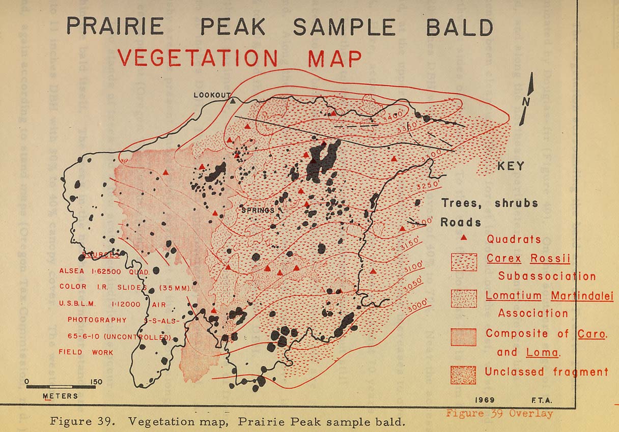
Map
D.05 Prairie Peak prairies and trails, 1969.
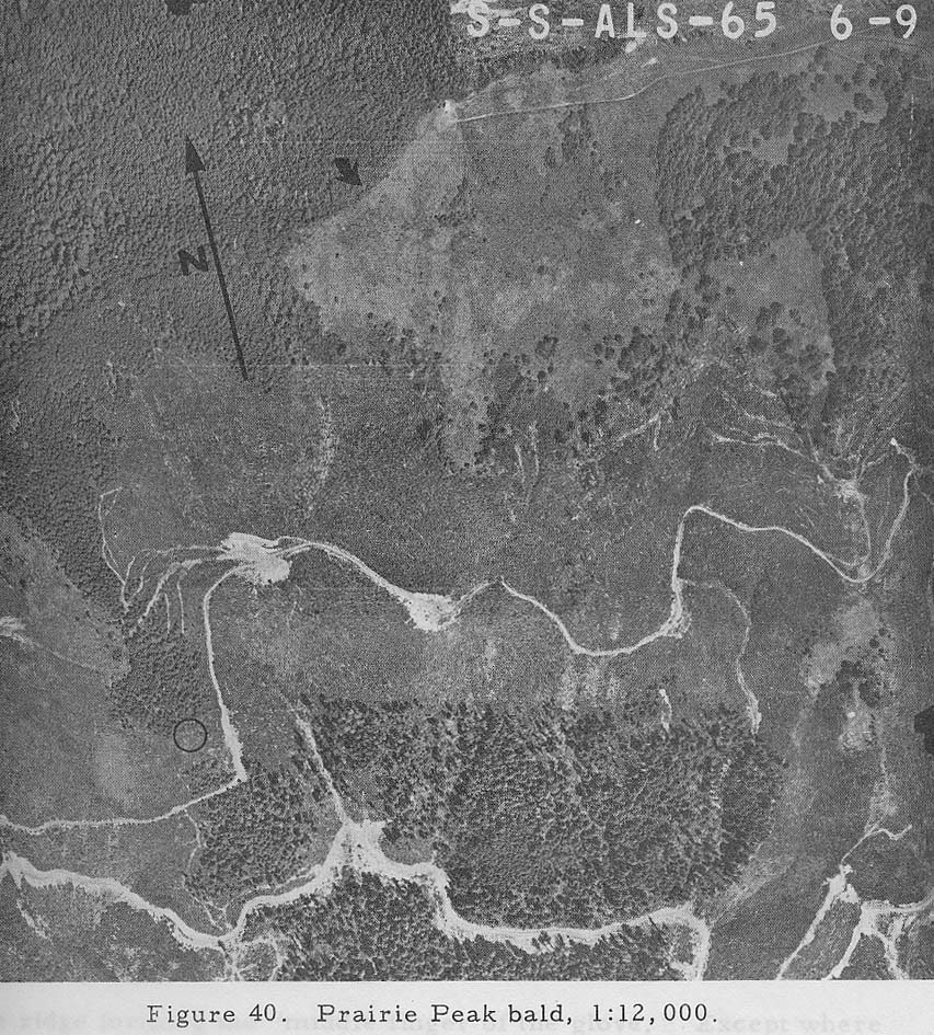
Fig. 3.02 Aerial photo of Prairie Peak
prairies and trails, 1967.
[Compare the vegetation patterns and
trails of Map D.05 and Fig. 3.02 with
|
Sec. 1
|
[1/36 ?]
I began at said SW. cor. Of sec. 36 where I found part of
the post described in original notes, burned or rotted down. (Collier 1892:
168).
|
|
|
41.50
Left timber and enter prairie, bears E. and W.; this
prairie extends in an easterly and westerly direction about 1 1/2 miles each
way.
|
|
|
55.00
Summit of Blue Mountain bears E. and W., elevation about
150 ft. above 1/4 S. cor[ner].; this is one of the highest mountains in the
Coast Range. (Gesner 1891: 418)
|
|
|
31.50
Cattle trail, course S. 75 W. and N. 75 E.
|
|
|
Trail to Prairie Mountain, course 75o E., and S. 75o W.,
on top of ridge of same (Collier 1893: 197)
|
|
|
33.25
Top of Blue Mountain, a sharp rocky ridge, bears N. 75 E.,
S. 75 W.; elevation above cor[ner]. To secs. 11, 12, 13 and 14 about 700 ft.
(Gesner 1891: 421)
|
|
|
29.25
oak, 12, 8”. “Left timber and entered prairie; this
prairie extends easterly several miles along the top of Blue Mountain.”
(Gesner 1891: 424).
|
|
Sec. 2
|
Bagley 1915
Yellow fir is good quality and generally sound except in
SW 1/4 SW 1/4 and SE 1/4 NE 1/4 where there is considerable defect in the old
growth timber. Hemlock is thrifty growth but low in clears. Cedar is good
for posts only. This section will be easy to log. . . . Fire damage as shown
on plat [14 acres]. The fire risk is nominal.
|
|
Sec. 4
|
[W mile between 4 and 33]
. . . A fir, 6 ins. . . . A fir, 7 ins. . . . Trail to
Prairie Mountain . . . A hemlock, 20 ins. . . . A fir, 40 ins. . . . A yew,
12 ins. . . . A vine maple, 6 ins. . . .Heavily timbered with fir and
hemlock; old growth dead on west 44.50 chs., but young growth in thickets
taking its place. Dense undergrowth of salala and rhododendron on last half
(Collier 1893: 172-173)
|
|
Sec. 7
|
|
Tsp. 15
S., Rng. 8 W. (15-8): Lobster River
General
Description
[David D.
Fagan 1885: 498] Conterminous
to the valley of the Alsea is a considerable quantity
of partially settle country. For eight or ten miles
to the southward, until Lobster creek is
reached, the land is rolling and productive; while
along the valley last-named there is a general settlement,
but plenty of room for more.
[Alonzo
Gesner, May 29, 1891] The townships on the east [14-7], south [15-8]
and west [14-9] are settled with a
class of people who intend making homes for themselves.
[Alonzo
Gesner, July 28, 1891: 443] This Township is mountainous
in character, some portions of it being quite broken.
There are about ten
settlers along the Lobster River, a tributary of Five
Rivers. . . Nearly the entire Township is covered with
a dense undergrowth . . . A voting precinct,
Post Office and school district are located in this township.
|
Sec. 1
|
[N mile between 1 and 6]
A dead fir, 26 ins. . . . A dead fir, 20 ins. . . .
[Bummer] Creek . . . Top of ridge . . . A dead fir, 30 ins. . . . foot of
Blue Mountain [Prairie Peak], ascend . . . Timber, fir and hemlock, generally
burnt wood. Dense undergrowth of hemlock, fir, huckleberry, thimbleberry,
salalberry and arrowood (Gesner 1891: 419)
|
|
|
|
|
|
|
|
|
[W mile between 1 and 36]
[Bummer] Creek . . . pass over spur. A dead fir, 12 ins.
. . . Top of ridge . . . Ravine . . . An alder, 10 ins. . . . A red fir, 6
ins. . . . Top of ridge . . . [Swamp] Creek . . . A red fir, 6 ins. . . . . A
red fir, 20 ins. . . . A cedar, 30 ins. . . . A red fir, 8 ins. . . . Timber,
burned fir and cedar, alder along the streams. Dense undergrowth of vine
maple, thimbleberry, cherry, myrtle [?] and hazel (Gesner 1891: 251-252)
|
|
Sec. 2
|
[W mile between 2 and 35]
Top of ridge . . . The top of Elkpone, bears S. 450 E.,
about 10 chs. dist. which is a round top mountain . . . A dead fir, 48 ins. .
. . A red fir, 36 ins. . . .A dead fir, 30 ins. . . .Top of ridge . . . A
dead fir, 48 ins. . . . A dead fir, 48 ins. . . . An alder, 15 ins. . . . An
alder, 8 ins. . . . Timber, burnt. Dense undergrowth of vine maple,
thimbleberry, and wild grape (Gesner 1891: 252-253)
|
|
Bagley 1915
|
Yellow fir is a fair grad, medium length. Red fir and
piling is young sappy timber and has no clears, fit for ties and dimension
only. Cedar is a fair grade suitable for shingles . . . No fire damage of
recent date and there is not much danger from fire at this time. This [SW]
1/4 section is of very little value as there is very little timber in this
locality and the timber is patchy and quite small except a little old timber
on the extreme east side. The country on the east for some distance is
brushy with small patches of timber and to the north it is all burned. To
the west there is a little young timber and a great deal of burn.
|
|
Sec. 3
|
“Timber, scattering fir, mostly burnt alder along stream,
92 chains” (Gesner 1891: 428).
|
|
|
[W mile between 3 and 34]
[Meadow] Creek . . . Same creek . . . A small lot . . .
Trail . . . Little Lobster . . . A maple, 10 ins. . . . A maple, 10 ins. . .
. A maple, 10 ins. . . . A red fir, 50 ins. . . . A red fir, 50 ins. . . . A
red fir, 16 ins. . . . Timber, scattering fir, alder and maple. Dense
undergrowth of vine maple, hazel, fir, wild grape and thimbleberry (Gesner
1891: 253-254)
|
|
Young, Mrs. 1891
|
(Gesner 1891: 432)
|
|
|
|
|
|
|
|
Sec. 4
|
“Timber, scattering and burnt fir, cedar and alder along streams”
(Gesner 1891: 432)
|
|
|
[W mile between 4 and 33]
Descend. Wagon road from Lobster to Alsea . . . Mr.
Joseph Cox's house [14-8-33]. . . about 15 chs. . . . A red fir, 12 ins. . .
. A red fir, 18 ins. . . . A dead fir, 36 ins. . . . Wagon road . . . Same
road . . . Same road . . . Mr. Hoge's garden . . . Wagon road . . . near old
fir stump . . . Timber, fir and alder, 80 chs. Dense undergrowth of vine
maple, hazel and thimbleberry (Gesner 1891: 254-255)
|
|
Bagley 1915
|
A few scattering yellow fir of good quality. Red fir is a
young and rapid growing timber, fit for ties and dimension only at this time.
Piling is same kind of timber and will soon make saw logs . . . No recent
fire damage but the old fire killed the old timber and it is growing up to young
fir and alder. Not much fire risk now.
|
|
Sec. 5
|
[4/5 S]
Top of ridge and divide bet. Little and big Lobster . . .
Wagon road and fence . . . A fir, 50 ins. . . . 195 lks. . . . A fir, 60 ins.
. . . 242 lks. . . .Wagon road . . . Young’s field, fence . . . A. M. Peek’s
house . . . barn . . . Mr. Young’s house . . . barn . . . Mr. Bratton’s house
. . . barn . . .Mr. Young’s fence . . . Lobster River . . . river bottom . .
. Timber, fir, maple, alder and cedar. Undergrowth of vine maple, cherry,
salalberry and thimbleberry (Gesner 1891: 436-437)
|
|
Peek, A. 1891
|
A. M. Peek’s house . . . barn (Gesner 1891: 436)
|
|
Bratton 1891
|
Mr. Bratton’s house . . . barn (Gesner 1891: 436)
|
|
Young, Mr. 1891
|
Wagon road . . . Young’s field, fence . . . Mr. Young’s
house
|
|
|
. . . barn . . . Mr. Young’s fence . . . Lobster River .
. . river bottom (Gesner 1891: 436)
|
|
|
[W mile between 5 and 32]
Creek . . . pass over sspur . . . Creek . . . pass over
spur . . . Creek . . . A red fir, 24 ins. . . . A red fir, 18 ins. . . .
Stream . . . pass over spur . . . Stream . . . pass over spur . . . Stream .
. . pass over spur . . . Stream. . . A red fir, 14 ins. . . . A red fir, 16
ins. . . . A red fir, 12 ins. . . . A red fir, 14 ins. . . Timber, fir,
alder, cherry and maple. Dense undergrowth of vine maple, cherry, hazel and
thimbleberry (Gesner 1891: 255-256)
|
|
Sec. 6
|
[5/6 S]
Ascend. Top of hill and divide bet. Little and big
Lobster . . . An alder, 20 ins. . . . A fir, 10 ins. . . .Enter Mr. G. C.
Peak’s calf pasture, fence . . . Left pasture, entered orchard, fence . . .
Entered river bottom. Mr. G. C. Peek’s house and Lobster post Office bears .
. . 75 lks. . . . Wagon road from Lobster to Alsea . . . Mr. G. C. Peek’s
barn, bears 150 lks. . . .Entered G. C. Peek’s grain field . . . Left grain
field and right bank of Lobster River . . . Left Lobster River bottom and
foot of hill . . . Top of ridge . . . Timbered with scattering fir, cedar,
maple and alder . . . Undergrowth, vine maple, hazel, cherry and salalberry
(Gesner 1891: 442-443)
|
|
|
[W mile between 6 and 31]
. . . A red fir, 32 ins. . . A chittem, 8 ins. . . . A
cedar, 30 ins. . . .A small spring . . . Top of ridge . . . Timber,
scattering fir, alder, cherry and maple . . . Undergrowth of vine maple,
cherry, hazel and salal berry (Gesner 256-257)
|
|
|
[S mile between 1 and 6]
Descend. A red fir. A cluster of dogwood, about 12 in
No. . . . A cherry, 8 ins. . . . A red fir, 10 ins. . . . Top of hill . . .
Wagon road . . . Fence . . . Enter Mr. Sapp's yard and orchard. The NE. cor.
Of school house in Dist. No. 46 . . . 256 lks.; the NW. cor. Of Mr. John
Sapp's house [15-7-7]. . . 318 lks. Fence, leave orchard and yard . . . A
maple, 26 ins. . . . An ash, 10 ins. . . . An alder, 5 ins. . . ., An alder,
12 ins. . . . An ash, 8 ins. . . . Timber, fir, maple, alder and dogwood,
mostly burned. Dense undergrowth, vine maple, salal, berry, salmon berry,
wild cherry and dogwood (Gesner 1891: 415-416)
|
|
Peek, G. 1891
|
Enter Mr. G. C. Peak’s calf pasture, fence . . . Left
pasture, entered orchard, fence . . . Entered river bottom. Mr. G. C. Peek’s
house and Lobster post Office bears . . . 75 lks. . . . Wagon road from
Lobster to Alsea . . . Mr. G. C. Peek’s barn, bears 150 lks. . . .Entered G.
C. Peek’s grain field . . . Left grain field and right bank of Lobster River
(Gesner 1891: 442)
|
|
Sec. 7
|
[6/7 E]
J. Sapp’s pasture, fence . . . Lobster River . . . Same
river . . . J. Sapp’s field, fence . . .An ash, 12 ins. . . . An ash, 36 ins.
. . . Timbered with fir, cedar, maple, hazel, salmonberry, gooseberry and
salalberry (Gesner 1891: 441)
|
|
Sapp 1891
|
Wagon road . . .Fence . . . foot of hill. Enter Mr. John
Sapp’s yard and orchard . . . the NW cor. Of Mr. John Sapp’s house bears . .
. 318 lks. . . . fence, leave orchard and yard (Gesner 1891: 415). J. Sapp’s
pasture, fence . . . Lobster River . . . Same river . . . J. Sapp’s field,
fence (Gesner 1891: 441)
|
|
Sec. 8
|
“Heavily timbered, south-half mile, green fir, alder,
maple and cedar; north-half mile, mostly burned woods.” (Gesner 1891: 440)
|
|
Sec. 9
|
[9/10 N] Mr. Tucker . . . B. W. Jenkin . . . James Morgan
|
|
Tucker 1891
|
(Gesner 1891: 429-430)
|
|
Jenkin 1891
|
|
|
Morgan 1891
|
[4/9 W] B. F. Smith (Gesner 1891: 435]
|
|
Smith 1891
|
|
|
Sec. 11
|
“Timber, burned woods, fir and scattering cedar” (Gesner
1891: 423)
|
|
|
“Timber, burnt fir and cedar, 80.60 chains” (Gesner 1891:
427)
|
|
Sec. 12
|
[N mile between 7 and 12] A red fir, 24 in. . . . A red
fir, 24 in. . . . A red fir, 24
in. . . . Left timber and enter prairie, bears E. and W.;
this prairie extends in an easterly
and westerly direction, about 1
1/2 miles each
way. Summit of Blue Mountain [Prairie
Peak] bears E. and W. . . . this
is one of the highest mountains
in the Coast Range. Descend. A red fir, 30 in.
. . . A hemlock, 20 in. . . . A
hemlock, 20 in. . . . A red fir,
32 in. . . . A red fir, 30 in. .
. . Timber, red fir and hemlock, 65
chs. Dense
undergrowth of fir, hemlock, vine
maple, hazel and huckleberry (Gesner
1891: 418)
|
|
Sec. 15
|
Entered Lobster River bottom, at foot of Blue [Prairie]
Mountain Trail. Bears N. 400 W. and S. 400 E. Lobster River, 75 lks. Wide,
on line, runs N. 350 W. (Gesner 1891: 429)
|